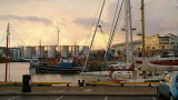
Small port. Suitable for yachts of all size (the Volvo ocean stopped there once). Convenient for shopping as Galway is a major city, and the harbour is a very short walk from the city centre. You can dry out along one of the quays or get a berth at the marina at the dock. Galway ...
La baie est tres bien protegee, et accessible de jour comme de nuit par tous les temps. Par mauvais temps, Cashla bay est l'un des abris les plus surs entre l'embouchure de la Shannon et Clew bay. Rossaveal est un port de peche et un des ports utilises par les ferries pour les ...
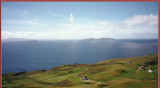
Clare Island is an island guarding the entrance to Clew Bay. The permanent population is around 120 people and the island has a shop with a post office, two bars, a restaurant, a few BnBs, a primary school and a daily ferry service to Roonagh quay. The island is the highest ...
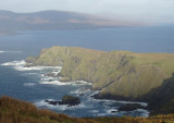
Marque l'entree de Kileany bay, le seul abri sur des iles d'Aran. Kilronan, a l'Ouest de la baie, est le port des ferries, et le petit port d'echouage de Killearny, 1 km au Sud (a cote de l'aeroport), est beaucoup plus sympatique, mais n'est accessible que deux heures de part ...