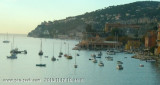
The port Darse S (South Dock) is located on the W side of the bay, S of the Villefranche Citadelle.
Tel 04 93 01 70 70
Fax 04 93 76 92 33
500 pl. (<30 m)
2012/03/29
Update
Le port de la Darse S est situé côté W de la rade au S de la citadelle de Villefranche-sur-Mer.
Tel 04 93 01 70 70
Fax 04 93 76 92 33
500 pl. (<30 m)
2012/03/29
Update
Bon accueil à la capitainerie. Sanitaires nickel-chrome, par contre les amarrages sont merdiques (port géré par la CCI des Alpes Maritimes ) et non standardisées dans un port qui est saturé... Mieux vaut prévenir à l'avance !!!
Le Cap d'Ail marque la séparation entre les baies de Beaulieu et de Monaco. Les abords étant malsains, il faut s'en écarter assez largement. Le cap Martin est couvert de pins d'où émerge un sémaphore blanc sur les hauteurs.
The Presqu'ile de Saint Hospice , 40m high, forms a peninsula which extends E from the center of the E side of the Cap Ferrat promontory. It is surmounted by a chapel and a conspicuous tower Pointe Saint Hospice, located 1.2 miles NE of the Cap Ferrat Light, is the E extremity of ...
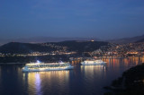
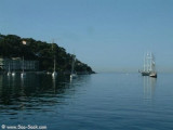
Rade de Villefranche is entered between Pointe des Sans Culottes, the SE extremity of the Mont Boron promontory, and Pointe Malalongue, the SW extremity of Cap Ferrat, 1 mile SE. The bay extends N for 1.5 miles and offers sheltered anchorage to vessels of any size. It is used by vessels ...
The harbourg of La Sante, on the W coast of the roads to the N of the citadel, shelters fishing boats, and in the southern part of it is a terminal with a landing stage for the launches providing the ferry service for the passenger cruise ships anchored in the roads. 36 berths (<15 ...
Zone importante de mouillage surtout avec du vent d'Est. On peut mouiller également- un peu plus au nord: anse Grassuet- au sud: anse de Passable : un peu de sable et beaucoup d'herbiers


 canal 9


 Poste informatique disponible à la capitainerie
 The port Darse S (South Dock) is located on the W side of the bay, S of the Villefranche Citadelle.
 Le port de la Darse S est situé côté W de la rade au S de la citadelle de Villefranche-sur-Mer.