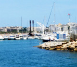
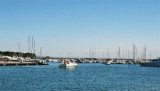
The port of Cambrils was a beach from the Middle Ages to the mid-twentieth century when the port was built to take refuge against regression beaches of Cambrils. From the 60s, part of the harbor was intended as a marina, which is managed by the Club Nautique de Cambrils.
Tel: 977 360 531
Fax: 977 362 654
Mail: cndc@infonegocio.com
407 b.
2012/06/12
Update
Jojo
Le port de Cambrils était une plage depuis le Moyen Age jusqu’à la moitié du XXe siècle où le port a été construit pour se réfugier face à la régression des plages de Cambrils. A partir des années 60, une partie du port fut destiné comme port de plaisance, dont la gestion est assurée par le Club Nautique de Cambrils.
In N Tortosa Cape, the low and swampy coast of the delta of the Ebro is oriented NW, and before its junction with the mainland, a peninsula of sand is detached forming bays of the Ampolla and del Fangal.Ampolla bay lies between ...
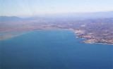
Rada de Salou extends from Riera de Riudoms point to Salou cape.The roadstead is sheltered from winds from the NW through N to E and affords anchorage in depths of 10/12 m, good holding ground, sand and weed, about 0,3 NM offshore.
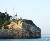
Salou cape is a rocky outcrop, 79 m high, jutting into the sea. From a distance it appears as an island because of the low coast which extends its side N.
A 11 m tall lighthouse, with a radio beacon, stood on the cape.


 Canal 9


 The port of Cambrils was a beach from the Middle Ages to the mid-twentieth century when the port was built to take refuge against regression beaches of Cambrils.
 Le port de Cambrils était une plage depuis le Moyen Age jusqu’à la moitié du XXe siècle où le port a été construit pour se réfugier face à la régression des plages de Cambrils.
")