In N Tortosa Cape, the low and swampy coast of the delta of the Ebro is oriented NW, and before its junction with the mainland, a peninsula of sand is detached forming bays of the Ampolla and del Fangal.
Ampolla bay lies between Punta del Fango and Cabo Roig.
Fangal bay is very low and it is not possible to anchor.
2012/06/8
Update
Jojo
Dans le N du cap Tortosa, la côte basse et marécageuse du delta de l'Ebre s'oriente au NW et, avant sa jonction avec la terre ferme, une presqu'île de sable s'en détache formant les baies de La Ampolla et Del Fangal.
La baie de La Ampolla s'étend entre la pointe del Fango et le cap Roig.
La baie del Fangal est trop peu profonde pour pouvoir y mouiller.
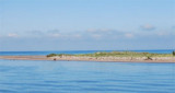
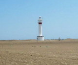
The sand peninsula, N Tortosa cape, has a lighthouse at its NW point, Punta del Fango. The lighthouse tower, 18 m high, is standing 1,5 NM E of the point.The point is extended to approximately 0.3 MN by a sandbar covered with 0.80 m of water.
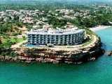
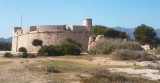
Roig cape, 6 m high, is is separated from the Figuera point by a cove bordered of a beach. It is located 1 NM NW of the village of La Ampolla.
An hotel is standing on the aera of the cape.
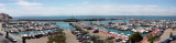
Located a few miles from the Ebro Delta and S Roig cape, The Yacht Club Ampolla is well protected. Dangers: Banks Arena on the area of Fangal; Beware Mistral (NW). Note that the water level drops or rises very significantly depending on whether the winds are from ...
Ametla harbour is an authentic fishing port where auction sales are renowned for the quality of its products.
In the heart of the Costa Dorada, Ametlla is approximately 3 hours from the French border. Ametlla port is one of the most important of Catalonia, as much by the ...


 In N Tortosa Cape, the low and swampy coast of the delta of the Ebro is oriented NW, and before its junction with the mainland, a peninsula of sand is detached forming bays of the Ampolla and del Fangal.
 Dans le N du cap Tortosa, la côte basse et marécageuse du delta de l'Ebre s'oriente au NW et, avant sa jonction avec la terre ferme, une presqu'île de sable s'en détache formant les baies de La Ampolla et Del Fangal.
")