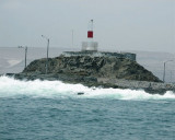

Morro de Arica (N Chile)
0.6nm
180°
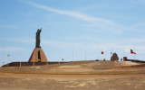
During the War of the Pacific (1879-1880) the morro de Arica was taken by Chilean troops in a heroic deed after only one hour of fighting against the Peruvian-Bolivian army. This historical ...
12 Dec 12
Joëlle
| Latitude | Longitude | |
| DMS | --- | --- |
| DM | --- | --- |
| DD | --- | --- |
 8, 14, 16
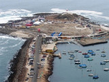
 Arica is a port city which lies at the SE end of the bay of the same name. It is the capital of the province of Arica, in the region of Arica Panaricota. It is known as the "City of Eternal Spring".
It was the scene of one of the most famous episodes of the Pacific War (1879/1884), taking the "Morro de Arica" in 1880. Until that time, the city was part of Peru.
Port is more important for the transhipment of goods to and from Bolivia for local imports and exports. Bolivia has maintained a customs at the port.
tel: 56 (58) 202080
Fax: 56 (58) 202090
Mail: puertoarica@puertoarica.cl
")
 Arica est une ville portuaire qui se trouve à l'extrémité SE de la rade du même nom. C'est la capitale de la province d'Arica, dans la région d'Arica Panaricota. Elle est connue comme la "ville de l'éternel printemps".
Le port est plus important pour le transbordement des marchandises vers et depuis la Bolivie que pour les importations et exportations locales. La Bolivie a maintenu une douane dans le port.
Le port se compose de deux brise-lames, un sur le côté N, s'étend vers l'WNW sur environ 450 m le long de la côte et une plus grande digue, sur le côté W du port (Muelle de Abrigo).
tel: 56 (58) 202080
Fax: 56 (58) 202090
Mail: puertoarica@puertoarica.cl
")
Ebook | Chile
|