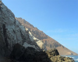
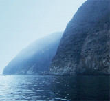
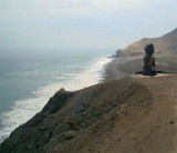
Morro de Arica (110 m high) is a hill that falls steeply into the sea, S Arica city.
During the War of the Pacific (1879-1880) the morro de Arica was taken by Chilean troops in a heroic deed after only one hour of fighting against the Peruvian-Bolivian army. This historical feat took place in June 7, 1880 and ever since has marked the northern territorial boundaries of the country.
To commemorate this, a museum has been built inside the small fort.
There is also a giant Jesus monument meant to symbolise reconciliation between Chile and Peru.
2012/12/12
Update
Joëlle
2012-12-12
Update
Joëlle
Morro de Arica (139 m de haut) est une falaise qui tombe à pic dans la mer, au S de la ville d'Arica.
Pendant la guerre du Pacifique (1879/1880) Morro de Arica a été pris par les troupes chilennes dans un acte héroïque, après seulement 1 h de combat contre l'armée Péruvienne-Bolivienne. Cet exploit historique a eu lieu le 7 juin 1880 et marque depuis les limites territoriales Nord du pays.
En souvenir de cette bataille, un musée a été construit à l'intérieur d'un petit fort.
Un christ géant a été aussi construit pour symboliser la réconciliation entre le Chili et le Pérou.
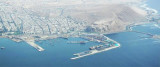
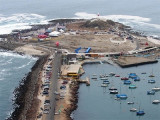
S Acra commercial harbour is Alacran island connected to the mainland by a road, from is where a small dock. A small breakwater extends from the island.
100 mooring buoys. Draught max: 18 m Length max: 25 m
Arica is a port city which lies at the SE end of the bay of the same name. It is the capital of the province of Arica, in the region of Arica Panaricota. It is known as the "City of Eternal Spring". It was the scene of one of the most famous episodes of the Pacific War (1879/1884), ...
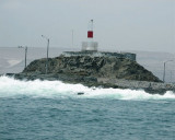
Au S du port d'Arica, sur l'île d'Alacran, se trouve un phare, tour cylindrique rouge et blanche, haute de 26m. A côté du phare, il y a un vieux fort espagnol, construit pour protéger l’entrepôt royal de Potosi (argent) et le port d'Arica des attaques des pirates.


 Monument National
 Morro de Arica (110 m high) is a hill that falls steeply into the sea, S Arica city.
 ")
 Morro de Arica (139 m de haut) est une falaise qui tombe à pic dans la mer, au S de la ville d'Arica.
")
")