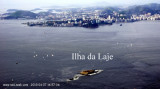
The entrance of the Guanabara bay lies between Ponta de Santa Cruz, about 6 miles WNW of Ponta de Itaipu and Ponta de Sao Joao, about 0.9 mile to the W.
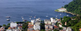
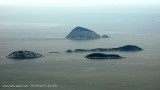
Ilhas Cagarras, about 3 miles N of Ilha Redonda, consists of seven islets. Ilha Comprida is the largest of the group. Ilha de Palmas shows a light. Sunken rocks extend 183m S of the E end of Ilha de Palmas. Ilha do Pai and Ilha da Mae lie on the NE side of the approach to Baia ...
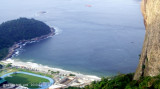
Urca Beach is a small, narrow beach 100 meters long, located at the foot of the hill of Urca; It is also the main beach of Urca in Rio de Janeiro, frequented by neighborhood residents.
The water is totally calm but has a dark tone because of pollution and it is considered unfit for swimming.
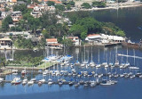
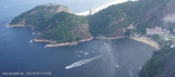
The marina entrance presents no difficulty. Once past the narrow that's all right then to starboard in the Bay of Jurujuba, in the territory of Niteroi. The marina is located S of the bay. One can steer to the marina as soon as it comes into view.


 The entrance of the Guanabara bay lies between Ponta de Santa Cruz, about 6 miles WNW of Ponta de Itaipu and Ponta de Sao Joao, about 0.9 mile to the W.