Mahabalipuram is about 35 km from Chennai. Mahabalipuram also known as Mamallapuram was
an important port built by Pallavas during the Seventh Century for the
maritime trade with the countries of South East Asia and Mediterranean.
In the ancient times the log fire on one of the high rocks used to serve
as beacon for the vessels approaching t Mahabalipuram port during the
night.
A dressed stone masonry circular tower 26m in height was built on a nearby rock in 1900. The PV source was replaced by incandescent electric lamp in 1994.
The Madras Light House is a lighthouse facing the Bay of Bengal. It is a famous landmark on the Marina Beach in Chennai. The lighthouse was opened in January 1977. It is one of the few lighthouses in the world and the only one in India with an elevator. The currents N of Chennai ...
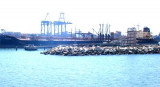
Chennai Port, formerly known as Madras Port, is the second largest port of India, behind the Mumbai Port, and the largest port in the Bay of Bengal and the principal harbor of Coromandel coast.
It is an artificial and all-weather port with wet docks that front s the center ...
Ennore Port, about 24 km north of Chennai Port, is the first port in India which is a public company. Ennore Port lies on the northeastern corner of the state of Tamil Nadu on a flat coastal plain known as the Eastern Coastal Plains, on the Coromandel coast.Depths—LimitationsThe ...
Ennur Shoal, with depths of 0.9 to 8.5m, extends 2.5 miles NE from a position on the coast about 10.5 miles NNE of Chennai Harbor. The coast between Chennai and Ennur, about 9.5 miles NNE, is bordered by plantations of casuarina and palm trees.
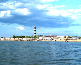
Pulicat Shoals, a chain of hard, sandy patches with depths ranging from 4.3 to 9.1m, extends about 7.5 miles NNE from the N end of Ennur Shoal. Several detached patches, with depths of 8.2 to 11m, lie within 3.8 miles N and NNW of the N end of Pulicat Shoals. These shoals were ...
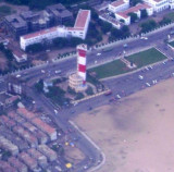
The Lighthouse station is separated from Pulicat town by a sea water channel. The town of Pulicat lies on an island at the S end of Pulicat Lake and is visible from the offing. A tall conspicuous monument lies close N of the lighthouse near the beach. The lighthouse at this ...


 Mahabalipuram is about 35 km from Chennai. Mahabalipuram also known as Mamallapuram was
an important port built by Pallavas during the Seventh Century for the
maritime trade with the countries of South East Asia and Mediterranean.
Mahabalipuram is about 35 km from Chennai. Mahabalipuram also known as Mamallapuram was
an important port built by Pallavas during the Seventh Century for the
maritime trade with the countries of South East Asia and Mediterranean.")