C'est la partie centrale de la plaine orientale, encadrée à l'ouest par le massif montagneux et à l'est par de longues plages bordées de pins et d'eucalyptus. La commune s'étend sur les domaines agricoles environnants, du plan d'eau de Teppe Rosse (à l'ouest), à l'étang de Diana (au nord-est), et au pénitencier de Casabianda (au sud-est). Elle est traversée par le fleuve Tavignanu qui achève ici sa course dans la mer. Le bourg U Cateraghju domine le fleuve légèrement en retrait de la côte.
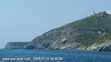
Capo Sagro is located at 11 NM. S Finocchiarola islands. He has a signal station and a semaphore rises N of it. Mount Merizatodio, 778 m high, is 1.5 MN to W Cape and dominates the immediate area.
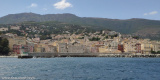
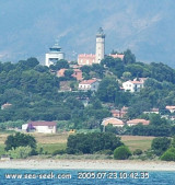
The village of Erbalunga, situated 1.5 miles SSW of Capo Sagro, stands on the S ...
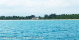
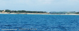
Bravone is located int the Costa Serena, a unique region, between sea and mountains, halfway between Bastia and Porto-Vecchio, at the mouth of the riverTavignano, closes S of the lagoon. This is a small seaside resort along the beach Linguizetta (name of town). It is possible to ...
Beautiful lagoon just north of Bastia, famous since antiquity for its oyster production: it has even, in the center of the lagoon, an island built of oyster shells!
Some fish species grow there before joining the waters of the Mediterranean, the conservatory littoral has bought ...
La tourelle Pecorella marque l'entrée de ce golfe qui s'enfonce à plus de 4 M dans les terres. Celle de Chiapino qui était plus au S est démolie. Il faut donc remonter suffisamment vers le N pour ne pas risquer d'en toucher les restes. En piquant vers l'W, la balise noire délimite ...
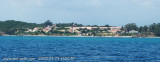
This lighthouse, commissioned in 1864, is located two kilometers inland to the tips of Alistro, at 1300 m. But report no particular danger, yet it is an essential reference point between Bastia and Solenzara, flat area and lagoon. The tower, ...