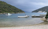

Otoci Skoji Korcula
3.7nm
124°
15 May 11
Jojo
| Latitude | Longitude | |
| DMS | --- | --- |
| DM | --- | --- |
| DD | --- | --- |


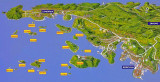
 Peljeski Kanal, leading between Otok Korcula and the W end of Poluotok Peljesac, is just over0.5 mile wide at its narrowest part and has depths of 18 to 55m over the route taken by ocean-going vessels.
The bora winds blow strongly in this channel and cause violent squalls in the E part; the scirocco winds blow fresh and usually produce a heavy and choppy sea.
During calms and light breezes, the current in the channel is generally tidal and its rate varies from 0.5 to 1.5 knots.
With winds of long duration, this current may attain a rate up to 3 knots.
The E entrance of the channel is obstructed by a group of islets which may best be seen on the chart.
Otocici Sestrice, consisting of two small islets, lies 2.7 miles NNE of Rt Raznjic and forms the NE and outer danger. A light is shown from a prominent structure, 12m high, standing on the NW and larger of the two islets.
Ocean-going vessels can take anchorage under the N shore of the channel, in depths of 18 to 36m, gravel and shells.
Small vessels can anchor in any of the coves and inlets along the Sshore of the channel.
Vessels over 500 grt and all vessels carrying dangerous substances or which have not been certified gas-free are prohibited from navigating through Peljeski Kanal.
In exceptional circumstances and with a pilot, the above-mentioned vessels of less than 5,000 grt may navigate in Peljeski Kanal from 1 October to 31 March. The pilot boards, as follows:

 Peljeski Kanal se trouve entre O. Korkula et la fin W de Poluotok Peljesac.Il est large de 0,5 NM à sa partie la plus étroite et a des profondeurs comprises entre 18 à 55 m. Ce chenal est fréquenté par les navires océaniques.
La Bora y souffle fort avec de violentes rafales dans la partie E; le Scirocco, vent frais provoque généralement une mer forte et agitée.
Par temps calme et légère brise, le courant dans le canal varie de 0,5 à 1,5 nœuds.
Avec des vents de longue durée, ce courant peut atteindre 3 nœuds.
L'entrée E du canal est encombrée par de nombreux îlots.
Otocicci Sestrice, composé de deux îlots, se trouve à 2,7 M au NNE de Rt Raznjic et représente le danger N extérieur. Un phare de 12 m de haut se trouve au NW de l'îlot le plus grand.
Les grands navires utilisent généralement le passage menant à l'E et au N de Otocici Sestrice; seulement les petits navires, avec des connaissances locales passent entre le groupe d'îlots au S et à l'W. En raison de la présence de nombreux petits bateaux les navires passant dans le Peljeski kanal ne doivent pas dépasser la vitesse de 12 nœuds.
Les navires de haute mer peuvent ancrer sur le rivage N du chenal, par 18 à 36 m, sur fond de gravier et coquillages.
Les petits bateaux peuvent jeter l'ancre dans une des criques et anses du rivage S du canal.
Attention.-Plusieurs câbles sous-marinset pipelinesse trouvent dans le voisinage de ces îles et îlots.
Les navires de plus de 500 grt et tous les navires transportant des matières dangereuses ou qui n'ont pas été certifiés comme exempts de gaz sont interdit de naviguer dans Peljeski Kanal.
Dans des circonstances exceptionnelles et avec un pilote, les navires mentionnés ci-dessus de moins de 5.000 tonneaux de jauge brute peuvent naviguer dans Peljeski Kanal à partir du 1er Octobre jusqu'au 31 Mars. Le pilote navigue, comme suit:
1. A environ 0,5 mile au SW de Rt Sveti Liberan.
2. Au NE de Sestrice.
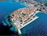
Ebook | Dubrovačko-neretvanska županija (Dubrovnik–Neretva
|
Ebook | Dalmacija (Dalmatie)
|