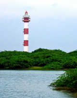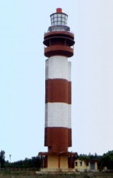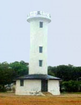

Karaikal lighthouse (Tamil Nadu-E India)
4.4nm
358°
25 Mar 12
Jojo
| Latitude | Longitude | |
| DMS | --- | --- |
| DM | --- | --- |
| DD | --- | --- |
 channel 16, 67, 71
")
Ebook | Bay of Bengal
|
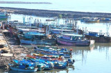
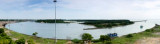
 Karaikal Port is a coastal lagoon type harbor located about about 200 miles S of Chennai (Madras) and about 9 miles S of the inland city of Karaikal.
Karaikal Port is a new harbor facility opened in 2009 to handle Panamax vessels up to 75,000 dwt, with a maximum length of 225m and a maximum draft of 13.0m. The port primarily handles cement, coal, rice, maize, and machinery.
The area has a monsoon climate comprised of a wet and dry season. During the summer wet season, generally from June into October, the predominant winds are from the SW at force 6 to 7. Most of the annual rainfall of nearly 1,270mm during this time, continuing into December. During the winter dry season, the predominant winds are from the NE at force 4 to 5.
The tides within the port area are semidiurnal, rising about 0.65m at MHWS, and 0.47m at MHWN, and about 0.2m at MLWN and 0.03m at MLWS.
The approach channel is dredged to a depth of 14.5m. A turning circle, with radius 190m, is located in the center of the harbor.
There are two berths, each 230m in length and dredged to a depth of 14.5m alongside.
The harbor protected by two breakwaters, with their seaward extents marked by lighted beacons.
About 0.5 mile N of the N breakwater is the Chemplast Pipeline, extending about 1,300m ESE from the coastline. About 0.6 mile S of the S breakwater, a jetty extends about 1,200m E from the coast.
Pilotage is compulsory for all vessels and requests should be made through the ships agents at least 3 hours prior to arrival. It should be noted that berthing at the Sanmar Marine Terminal takes place only during daylight hours and vessels heading to this terminal should contact Sanmar Port Control on VHF Channel 16 at least 3 hours prior to arrival.
Communications between the vessel and the Pilot is carried out on VHF channel 71. Pilot boards in position 10°50.2'N, 79°57'E, or 3 miles ENE of the jetty for vessels bound for Sanmar Marine Terminal.
Vessels should send their ETA to Karaikal Port Control starting 7 days, 5 days, 4 days, 3 days, 2 days, 24 hours, and 12 hours prior arrival.
The port can be contacted, as follows:
VHF: VHF channels 16 and 71
Tel: 91-4365-256600 or 91-9790-960448 (mobile)
Fax: 91-4365-256603
Mail: enquiries@karaikalport.com
Sanmar Marine Terminal can be contacted, as follows:
VHF: VHF channels 16 and 67
Tel: 91-4368-292846
Fax: 91-4365-256473
Caution.—The port remains under construction so it would not be unusual to see dredging and other heavy equipment within the harbor area. It has been reported that Phase 2 will add five berths with expected completion in 2012; Phase 3 will add nine more berths by 2015.