Otok KrK Kvarner

Otok KrK Kvarner

To precisely geolocate this site. Update if necessary.

Localisation

Otok KrK Kvarner
LatitudeLongitude
DMS------
DM------
DD------

Characteristics

Coast

Description

Otok KrK Kvarner
Otok KrK
2008-07-12
Update
Ebook

Kvarner

  • 120 sites
  • 182 photos
  • publication date: 7 Jul 2023
  • .pdf file size: 69 Mb
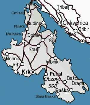
Krk (i Italian Veglia, in Latin Curicta) is a Croatian island in the northern Adriatic Sea. It is located in the Rijecki Zaljev, between the mainland at E and to W Otok Cres.
With its 405 km ² (exactly 405 218 994 m², very slightly smaller than Cres), Krk is the second largest island in the Adriatic area.
It is separated from the mainland by the Tihi Kanal, and is connected to the mainland by a bridge of two concrete arches since 1980. Measuring 1430 meters, is one of the longest concrete bridge in the world. Its vertical clearance of at least 50 m.
The N of the island is covered with crops and forests. The rest of Krk is a series of bare limestone hills.
The island has been inhabited since the tenth century BC. AD. The Romans called Curicta. -49 In September, during the Civil War, the bay has seen the fleet of Pompey defeat that of Julius Caesar.
More than a thousand years later, the island was the center of the dialect of the language végliote Dalmatian. She was also the seat of medieval bishops and a large nobility: the Frankopan.
The island has a small fishing fleet and an oil terminal in Omisalj. Tourism plays a role more important.
2011/08/2
Update
Jojo
Krk (en italien Veglia, en latin Curicta) est une île croate dans le nord de la mer Adriatique. Elle est située dans le Rijecki Zaljev, entre le continent à l'E et Otok Cres à l'W.

Avec ses 405 km² (exactement 405 218 994 m², très légèrement plus petite que Cres), Krk est la deuxième île adriatique en superficie.

Elle est séparée du continent par le Tihi Kanal, et est reliée au continent par un pont en béton de deux arches depuis 1980. Mesurant 1 430 mètres, c'est l'un des plus long pont en béton du monde. Son tirant d'air est d'au moins 50 m.

La partie N de l'île est couverte de cultures et de forêts. Le reste de krk est une suite de collines calcaires dénudées.

L'île est habitée depuis le Xe siècle av. J.-C.. Les Romains l'appelaient Curicta. En septembre -49, durant la guerre civile, la baie a vu la flotte de Pompée défaire celle de Jules César.

Plus de mille ans plus tard, l'île était le centre du dialecte végliote de la langue dalmate. Elle était également le siège d'évêques médiévaux et d'une importante noblesse : les Frankopan.

L'île abrite une petite flotte de pêche et d'un terminal pétrolier à Omisalj. le tourisme y joue un rôle de plus en plus important.

2011/08/2
Update
Jojo
Share your comments or photos on "Otok KrK Kvarner"

Sites around Otok KrK Kvarner

Flying distances - Direct line

Vinodolski Kanal

3.8nm
52°
Vinodolski Kanal is an extension of Velebitski Kanal and leads between the E side of Otok Krk and the mainland.
The channel, 9 miles long, extends NW from the vicinity of Novi Vinodolski to the S end of Tihi Kanal.
The Adriatic Highway follows the mainland coast, close inland, ...
1 Aug 11
Jojo

Otok Plavnik Kvarner

8.5nm
211°
Otok Plavnik lies with Rt Veli Pin, its N extremity, located 0.7 mile E of the E side of Otok Cres and divides Srednja Vrata in its S part into two channels.
This cliffy island is 194m high and partly wooded.
Several small islets lie on a shoal bank which extends about 1.5 miles ...
4 Aug 11
Jojo

Kanal Vela Vrata

16nm
282°
Kanal Vela Vrata connects the N end of Kvarner to Rijecki Zaliv and leads between the N end of Otok Cres, on the E side, and the mainland coast, on the W side.
The channel is deep and clear, the bottom being formed of mud.
31 Jul 11
Jojo

Kanal Krusija

8.6nm
213°
Kanal Krusija leads to the W of Otok Plavnik.
This channel is frequented because of its steep-to shores and deep passage.
A strong current may occasionally be experienced in this channel, depending on local weather conditions, but this passage is recommended over the one leading ...
4 Aug 11
Jojo

Tihi kanal

9.8nm
348°
Tihi Kanal, 3 miles long, connects the NW end of Vinodolski Kanal to Rijecki Zaliv.
The channel is deep and tortuous and leads between the mainland and the NE end of Otok Krk.
2 Aug 11
Jojo

Rapski Kanal

15nm
157°
Rapski Kanal is deep and leads between Otok Sveti Grgur and Otok Rab.
This channel is seldom used as the fairway is only 0.3 mile wide in places and several rocky patches lie adjacent to its S side.
4 Aug 11
Jojo