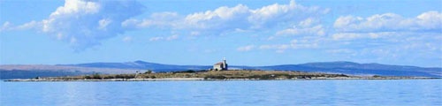
Otocic Trstenik, an islet fringed by a shoal bank, lies 2.5 miles NE of the SE end of Otok Cres. A light is shown from a prominent structure, 12m high, standing on the summit of this islet.
2011/08/4
Update
Jojo
Otocic Trstenik, un îlot bordé par un banc, est à 2,5 miles au NE de l'extrémité SE de Otok Cres. Un feu se trouve sur une structure haute de 12m, au sommet de cet îlot.
Olipski Kanal leads NNW between the E side of Otok Silba and the W side of Otok Olib and merges into the N end of Pohlipski Kanal. This channel is deep and has a minimum navigable width of 0.7 mile. It is often used by vessels proceeding to and from Zadar. Good anchorage is ...
Otok Olib is located E of O. Silba. It belongs to Zadar archipelago.The island has been inhabited since Roman times. The residents bought their island in 1900. The only village on the island was established around the port. To the east of the island you will find some small hidden ...
Kvarnericka Vrata, 5 miles wide, is the principal channel leading between the open sea and the S part of Mali Kvarneric. It lies between Otok Premuda and Otok Silba, on the S side, and Otok Ilovik, on the N side.
Premuda is located northwest of Otok Skarda which it is separated by a channel about 0.9 m wide (Premuda Vrata). The tips of each side of the channel are overwhelmed shoals and should not be approached too closely. The coast is home to 2 W moorings and a small port and there is ...
Otok Unije, a long and irregular shaped island, lies with Rt Vnetak, its SW extremity, located 7 miles NNW of Otok Susak and at W from N O. Losinj from it is separated by Unijski Kanal. The island consists of a chain of partly wooded hills and the summit, 132m high, stands in the ...
Otok Plavnik lies with Rt Veli Pin, its N extremity, located 0.7 mile E of the E side of Otok Cres and divides Srednja Vrata in its S part into two channels. This cliffy island is 194m high and partly wooded. Several small islets lie on a shoal bank which extends about 1.5 miles ...





 Otocic Trstenik, an islet fringed by a shoal bank, lies 2.5 miles NE of the SE end of Otok Cres.
 Otocic Trstenik, un îlot bordé par un banc, est à 2,5 miles au NE de l'extrémité SE de Otok Cres.