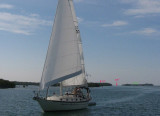
Northwest Channel is a medium-draft passage between Key West Harbor and the Gulf of Mexico. In May 2002, the midchannel controlling depth was 10 feet. Vessels can pass directly across the reefs from the Gulf to the Straits of Florida by way of Northwest Channel and Main Ship Channel. The Gulf end of the channel is shifting W. The jetties on either side of the Gulf entrance to Northwest Channel are 0.3 to 0.5 mile from the centerline of the channel, and only the outer part of the E jetty shows above low water. The NW end of the jetty is marked by a light. The channel is marked by lights, a 166° lighted range, daybeacons, and lighted and unlighted buoys. The steel pilings and skeletal tower of a former Coast Guard lighthouse are about 0.3 mile SW of the S end of the W jetty.
2012/04/9
Update
Cham
Nord-Ouest Channel est un passage entre le port de Key West et le golfe du Mexique. En mai 2002, la profondeur du milieu du canal a été contrôlé à 3 m. Les navires peuvent passer directement à travers les récifs du Golfe du Mexique vers le Détroit de Floride en passant par le canal NW et par Main Ship Channel. La fin du chenal NW se déplace vers l'W. Les jetées de chaque côté de l'entrée du chenal Nord-Ouest sont de 0,3 à 0,5 mile de la ligne médiane du canal, et seule la partie extérieure de la jetée E est bordée d'eau peu profonde. L'extrémité NW de la jetée est marquée par un feu. Le canal est balisé par des lumières, une balise 166 ° éclairée, balises de jour, et des bouées lumineuses et non lumineuses. Les pieux d'acier de la tour d'un ancien phare est à environ 0,3 mile au SW de la fin de la jetée S W.
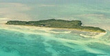
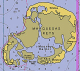
The Marquesas Keys (not to be confused with the Marquesas Islands (French Polynesia in the Pacific Ocean) form an uninhabited island group about 30 miles (50 km) west of Key West, 4 miles (6 km) in diameter, and overgrown by mangrove. They are protected as part of the Key ...
Boca Chica Key is an island in the lower Florida Keys approximately 3 miles east of the island of Key West. Its name is Spanish for "small mouth", (not "girl mouth" as many assume, since chica used as an adjective in Spanish means small).It is mainly composed of salt marshes (mangroves) ...
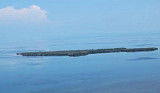
Cottrell Key is located in the Outlying Islands of the Florida Keys, it is the northernmost of the Mule Keys that are 9 miles (15 km) west of Key WestIt?s a popular spot for snorkeling. There are visible and easy to find remains of a wreck here, and it?s one of the few wrecks that ...
Fleming Key is an island off the northwest corner of the island of Key West, Florida in the lower Florida Keys. It is roughly 2 miles (3.2 km) long by a quarter mile wide. It is connected to the island of Key West by the Fleming Key Bridge. The island and bridge ...
Stock Island is an island in the lower Florida Keys immediately east of Key West (separated from Key West by Cow Key Channel, which is only about 75 yards (70 m) wide).Immediately northwest is Key Haven (official name Raccoon Key), from which it is connected by causeway with US 1 ...


 Northwest Channel is a medium-draft passage between Key West Harbor and the Gulf of Mexico. In May 2002, the midchannel controlling depth was 10 feet. Vessels can pass directly across the reefs from the Gulf to the Straits of Florida by way of Northwest Channel and Main Ship Channel.
 Nord-Ouest Channel est un passage entre le port de Key West et le golfe du Mexique. En mai 2002, la profondeur du milieu du canal a été contrôlé à 3 m. Les navires peuvent passer directement à travers les récifs du Golfe du Mexique vers le Détroit de Floride en passant par le canal NW et par Main Ship Channel.