Neretvanski Kanal, a continuation of Korculanski Kanal, is entered N of Rt Lovisce, the NW extremity of Poluotok Peljesa. It is wide and mostly free of dangers. This channel leads E for 11 miles and then SE for 9 miles where it narrows at the entrance to Malo More.
2011/05/1
Update
Jojo
Neretvanski Kanal, une continuation de Korculanski Kanal, commence au N de la Rt Lovisce, l'extrémité nord-ouest de Poluotok Peljesa. Il est large et surtout exempte de dangers. Ce canal s'étend à l'E sur 11 miles, puis au SE sur 9 miles où il se rétrécit à l'entrée de Malo Plus.
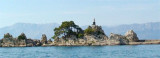
Skoji is a group of islands in Korcula Archipelago, located in Peljesac Channel in Croatia. There are all together 19 small islands that form this archipelago. Their names are : Badija, Kamenjak, Gojak, Planjak, Vrnik, Majsan, Majsanic, Gubavac, Knezic, Bisace, Sutvara, Stupe, Baretica, ...
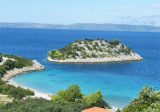
Small bay open to the N, easily identifiable by the small island Divna, located northwest of the entrance to the bay. We pass N of the island and anchor by 5 to 14 m.
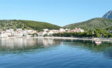
Trpanj is a small town on the north shore of the peninsula Peljesac in the Neretva channel, at the foot of Mt. vrh Velji (474 m) and Viter (629 m). This is the most famous tourist destination on the northern coast of Peljesac. It is connected to a service Ploce Ferry. The ...
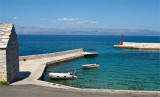
At E Rt Duba, the small port of Duba Lucica offers good shelter. The approach is safe. The village of Duba has a remarkable church. Moor at one of the quays along the space available. Exposed to the NW.
Uvala Drevnik is a small bay with a small fishing port on one side and a pier for the ferry that links with O. Hvar, on the other side. You can anchor in the bay, by 7 m. Sheltered N and E.
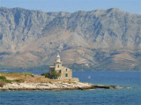
Rt Sucuraj, the E extremity of Otok Hvar, lies 2.5 miles from the mainland coast. This point is low and a chapel is situated on it. A light is shown from a prominent structure, 14m high, standing on the point.


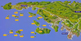


 Neretvanski Kanal, a continuation of Korculanski Kanal, is entered N of Rt Lovisce, the NW extremity of Poluotok Peljesa. It is wide and mostly free of dangers.
 Neretvanski Kanal, une continuation de Korculanski Kanal, commence au N de la Rt Lovisce, l'extrémité nord-ouest de Poluotok Peljesa. Il est large et surtout exempte de dangers. Ce canal s'étend à l'E sur 11 miles, puis au SE sur 9 miles où il se rétrécit à l'entrée de Malo Plus.