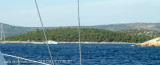
Otok Zirje (Sibenik)
12nm
292°
It is long of 6,5 NM (NW/SE) and 1,4 NM wide.
The main village, Zirje, is located in the middle of the island. A small port, luka Muna, on the coast N of Zirje, home to the ferry that connects the ...
16 Aug 11
Croatia
| Latitude | Longitude | |
| DMS | --- | --- |
| DM | --- | --- |
| DD | --- | --- |


 à Primosten


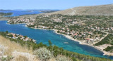
 La baie S de Kremik
 Luka Peles is a a "T" shape bay on the mainland, 3 NM NW of Rogoznica. The arm has been converted into N marina, arm S is reserved for local boats.
 Access from offshore. The marina is not visible.
 Luka Peles est une baie en forme de "T", sur le continent, à 3 NM au NW de Rogoznica. Le bras N a été aménagé en marina, le bras S étant réservé aux bateaux locaux.
Luka Peles s'identifie facilement grâce au feu de Rt Kremik, le cap au N de l'entrée.
Il est possible de s'amarrer le long du quai par 3 m, dans le bras S pour la journée.
La marina est bien protégée de tous les vents
C'est un port d'entrée l'été.
Tel: +385 (0)22 570 068
Fax: +385 (0)22
571 142
Mail: marina-kremik@primosten-hoteli.hr
393 pl.
150 pl. à sec
Ebook | Šibensko-kninska županija (Šibenik-Knin County)
|