Kanal Vela Vrata connects the N end of Kvarner to Rijecki Zaliv and leads between the N end of Otok Cres, on the E side, and the mainland coast, on the W side. The channel is deep and clear, the bottom being formed of mud.
The large natural inlet Zaljev Rasa offers the best protection of all sectors of the entire E coast of Istria, while the Bora blows strongly here. This bay is sinking into the earth near 6M, between Rt Ubac and Rt Mulac. The Rijeka Rasa flows into the bottom, creating a current that ...
Koperski Zaliv (Baia di Capodistria) is entered between Rt Ronco and Rt Debeli, 5 miles NE.The NE and SW shores of the bay are hilly, but the shore at the head of the bay, through which the Fiume Risano flows, is low. Monte Sermino, surrounded by salt beds, rises isolated in the river ...
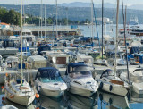
Icici Marina (or marina di Abbazia) is located in the town of Opatija, NW of Rijeka Bay, between Opatija and Icici, 40 km from the airport. The harbor basin is protected by a jetty with curved breakwater and a pier. Internally, several piers are arranged perpendicular to the shore.Depth: ...
Tihi Kanal, 3 miles long, connects the NW end of Vinodolski Kanal to Rijecki Zaliv. The channel is deep and tortuous and leads between the mainland and the NE end of Otok Krk.
Bakarski Zaljev is a bayalmost closed on the continent, and SE of Rijeca N O. Krk. It is entered 6 NM ESE of Rijeka and is accessible by a channel of 0.3 nm wide at its narrowest point. It is equipped with facilities for cargo. There is a shipyard in Kraljevica, an oil terminal ...


 canal 17


 Pharmacie

 5 T.
5 T.


 épicerie


 L'hôtel Admiral est un bon amer du large avec le nom en gros caractère à son sommet.