Luka Zlarin

Luka Zlarin

To precisely geolocate this site. Update if necessary.

Localisation

Characteristics

Port
Grass
Mooring Bonne tenue
Sand
Water quai extérieur. Robinet d'eausur la rive E du port
Phone
Electricity quai extérieur
First aid
Market
Grocery
Restaurant
Post
East cardinal Plic Mali Rozenik

Description

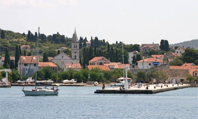
The village and port of Zlarin is at the bottom of a large bay, NW of the island.
The main dangers in the approach, are Plicina Rozenik Plicina Rozenik Mali, rock and shoals to the northwest of the nearest point N of Zlarin, Rt Velika ostrica. Plic Mali Rozenik is indicated by an E cardinal buoy without fire. There is a narrow passage to the SE by 11 m.
Northwest of the buoy, Plic Rozenik is signaled by a beacon fire.
We moored along the wharf outside the side N or S. The funds range from 0.5 m at the start of the pier, a good 5 m at the end.
You can anchor at the N or W of the ferry wharf by 5 m.
2011/07/9
Update
Jojo
Luka Zlarin
2011-07-09
Update
Jojo
Le village et le port de Zlarin se trouve au fond d'une large baie, au N de l'île.

Les principaux dangers dans l'approche, sont Plicina Rozenik et Plicina Mali Rozenik, rocher et hauts-fonds au NW de la pointe la plus au N de Zlarin, Rt Velika Ostrica. Plic Mali Rozenik est signalé par une bouée cardinale E sans feu. Il y a un passage étroit à son SE par 11 m.
Au NW de cette bouée, Plic Rozenik est signalé par une balise avec feu.

On s'amarre le long de l'appontement extérieur sur le côté N ou S. Les fonds varient de 0,5 m au départ de l'appontement, à un bon 5 m au bout.

On peut mouiller au N ou à l'W de l'appontement du Ferry par 5 m.

2011/07/9
Update
Jojo
Ebook

Šibensko-kninska županija (Šibenik-Knin County)

  • 99 sites
  • 182 photos
  • publication date: 7 Jul 2023
  • .pdf file size: 59 Mb
Share your comments or photos on "Luka Zlarin"

Sites around Luka Zlarin

Flying distances - Direct line

Otok Zirje (Sibenik)

7.4nm
247°
Otok Zirje is the farthest and the largest island in the Sibenik archipelago.
It is long of 6,5 NM (NW/SE) and 1,4 NM wide.
The main village, Zirje, is located in the middle of the island. A small port, luka Muna, on the coast N of Zirje, home to the ferry that connects the ...
16 Aug 11
Croatia

Zlarinski Kanal

1.4nm
189°
Zlarinski Kanal leads along the SW side of Otok Zlarin and is entered midway between Rt Rat and Otocic Komorica, a small islet marked by a light, 1.5 miles SW.
This channel is sometimes used as an alternate route to Sibenik by vessels entering Sibenska Vrata, the middle passage, ...
21 Jun 11
Jojo

Otok Murter

11nm
302°
The island of Murter is the largest island of the Sibenik archipelago. It is close to the coast on which it is connected by a bridge, low air draft at Tijesno (Tisno) on the continent. During the summer the bridge opens to allow passage of boats.
The NW part of the island is fertile ...
3 Apr 11
Jojo

Otok Zlarin Sibenik

0.8nm
153°
Otok Zlarin is 3.2 NM (NW / SE) by 1.2 nm and has only one village. Its highest point is Klepac (174 m).
Access to cars is prohibited.
It is located 2 km SW of Sibenik which it is separated by the Sibenski Kanal.
It has been inhabited since the Neolithic and was occupied ...
9 Jul 11
Jojo

Otok Kaprije (Sibenik)

5.8nm
268°
Kaprije is located in the central part of the Sibenik archipelago between the islands Zmajan and Kakan.
The highlight of the island is Vela Glavica (132 m).
The only village of the island is Kaprije, S. The port is busy.
Automobiles are not allowed on the island.
16 Aug 11
Croatia

Otok Svetac (Andrija)

40nm
184°
Otok Svetac (Andrija), 305m high, lies 13 miles ESE of Otocic Jabuka and is generally steep-to. The coast of the island is rocky and reddish in color on the NW side. Its SW end is fronted by a few rocks. Hrid Kamik, a dark and jagged above-water rock, lies 0.7 mile W of the SW extremity ...
25 May 11
Jojo