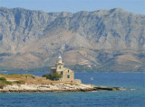
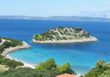
Luka Sucuraj Hvar

Luka Sucuraj Hvar

To precisely geolocate this site. Update if necessary.

Localisation

Characteristics

Port
Water
Phone
First aid
Market
Restaurant
Post
Bank

Description

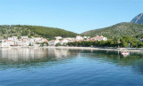
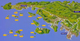
Sucuraj is theE nearest port of O. Hvar, it is located under the cape of the island and only 3 NM of  Drvenik on the continent.
It is a ferry terminal, but it remains a pleasant stopover for boaters.
The port is easily identifiable by day or night. It lies W of Rt Sucuraj on the S side of Hvar.
The entrance is narrow and there are submerged rocks near the shore to the east of the port.
It docks to the sea wall near the fire at the port or the S breakwater.
Good protection except from the E and SE.
2011/06/2
Update
Jojo
Luka Sucuraj Hvar
2011-06-02
Update
Jojo
Sucuraj est le port le plus à l'E d'O. Hvar, il est situé sous le cap de l'île et seulement à 3 NM de Drvenik sur le continent.
C'est un terminal de Ferries, mais il reste cependant une escale agréable pour les plaisanciers.

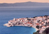
Le port est facilement identifiable de jour comme de nuit. Il se trouve à l'W de Rt Sucuraj sur la côte S de Hvar.
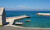
L'entrée est étroite et il y a des rochers submergés près du rivage à l'E du port.

On s'amarre à la digue près du feu du port ou au S du brise-lames.

Bonne protection sauf du SE et de l'E.

2011/06/2
Update
Jojo
Luka Sucuraj Hvar
2011-06-02
Update
Jojo
Luka Sucuraj Hvar
2011-06-02
Update
Jojo
Ebook

Dubrovačko-neretvanska županija (Dubrovnik–Neretva

  • 138 sites
  • 228 photos
  • publication date: 9 Jul 2023
  • .pdf file size: 74 Mb
Share your comments or photos on "Luka Sucuraj Hvar"

Sites around Luka Sucuraj Hvar

Flying distances - Direct line

Otoci Skoji Korcula

10nm
181°
Skoji is a group of islands in Korcula Archipelago, located in Peljesac Channel in Croatia. There are all together 19 small islands that form this archipelago. Their names are : Badija, Kamenjak, Gojak, Planjak, Vrnik, Majsan, Majsanic, Gubavac, Knezic, Bisace, Sutvara, Stupe, Baretica, ...
15 May 11
Jojo

Rt Sucuraj Hvar

0.3nm
96°
Rt Sucuraj, the E extremity of Otok Hvar, lies 2.5 miles from the mainland coast.
This point is low and a chapel is situated on it.
A light is shown from a prominent structure, 14m high, standing on the point.
30 May 11
Jojo

Uvala Drevnik (Donja Vala)

3.1nm
55°
Uvala Drevnik  is a small bay with a small fishing port on one side and a pier for the ferry that links with O. Hvar, on the other side.
You can anchor in the bay, by 7 m.
Sheltered N and E.
4 May 11
Jojo

Luka Igrane Makarska

4.6nm
333°
Igrane is a picturesque village on the Makarska Riviera. The village overlooks the sea, port, and the long beach of gravel and sand. Above the square is the steeple of the church of Our Lady of the Rosary which seems to watch over the village and its inhabitants. In the vicinity there ...
5 May 11
Jojo

Luka Lucica Duba Peljesac

6nm
187°
At E Rt Duba, the small port of Duba Lucica offers good shelter.
The approach is safe. The village of Duba has a remarkable church.
Moor at one of the quays along the space available.
Exposed to the NW.
27 Apr 11
Jojo

Uvala Divna Peljesac

6.5nm
174°
Small bay open to the N, easily identifiable by the small island Divna, located northwest of the entrance to the bay.
We pass N of the island and anchor by 5 to 14 m.
28 Apr 11
Jojo