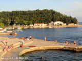
Selce is a small resort on the continent. Boaters can dock at a pier in the bay on the shores S and SE, that is open to the west. From the large or the S, one can read "TITO" written on the hill above the city. There is also a large hotel on the NW edge city and a remarkable bell tower topped by a spire. From the N, attention to a shoal covered with 4.8 m extending up to 1.5 million immediately from the coast northwest of Selce. Good protection from N to S by E.
2011/07/29
Update
Jojo
Selce est une petite station de vacances sur le continent. Les plaisanciers peuvent s'amarrer à une jetée dans la baie, sur les rives S et SE, qui est ouverte à l'W. En venant du large ou par le S, on peut lire "TITO" écrit sur la colline au-dessus de la ville. Il y a aussi un grand hôtel sur la pointe NW et en ville un clocher remarquable surmonté d'une flèche. En venant par le N, attention à un haut-fond recouvert de 4,8 m qui s'étend jusqu'à 1,5 M de la côte immédiatement au NW de Selce. Bonne protection du N au S par l'E.
Kanal Vela Vrata connects the N end of Kvarner to Rijecki Zaliv and leads between the N end of Otok Cres, on the E side, and the mainland coast, on the W side. The channel is deep and clear, the bottom being formed of mud.
Otok Plavnik lies with Rt Veli Pin, its N extremity, located 0.7 mile E of the E side of Otok Cres and divides Srednja Vrata in its S part into two channels. This cliffy island is 194m high and partly wooded. Several small islets lie on a shoal bank which extends about 1.5 miles ...
Tihi Kanal, 3 miles long, connects the NW end of Vinodolski Kanal to Rijecki Zaliv. The channel is deep and tortuous and leads between the mainland and the NE end of Otok Krk.
Rapski Kanal is deep and leads between Otok Sveti Grgur and Otok Rab. This channel is seldom used as the fairway is only 0.3 mile wide in places and several rocky patches lie adjacent to its S side.
Zaliv Soline, a nearly landlocked small bay, lies 1.5 miles WNW of Rt Silo and is entered through a narrow channel. Although there are depths of 10 to 12m over a width of 100m in the entrance, the bay has depths of only 2 to 4m and is used mostly by small craft.


 Ã la douche sur la plage
à la douche sur la plage

 sur la plage


 Selce is a small resort on the continent. Boaters can dock at a pier in the bay on the shores S and SE, that is open to the west.
 Selce est une petite station de vacances sur le continent. Les plaisanciers peuvent s'amarrer à une jetée dans la baie, sur les rives S et SE, qui est ouverte à l'W. En venant du large ou par le S, on peut lire "TITO" écrit sur la colline au-dessus de la ville. Il y a aussi un grand hôtel sur la pointe NW et en ville un clocher remarquable surmonté d'une flèche.