Luka Rijeka

Luka Rijeka

0.2 nm
To precisely geolocate this site. Update if necessary.

Localisation

Characteristics

Port
Water quais de commerce
Fuel
First aid Hôpital/Pharmacie
Mechanical repair
Shipchandler
Shipyard
Slip
Market
Grocery
Restaurant
Post
Bank

Description

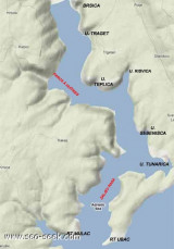
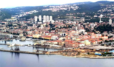
Rijeka is the largest Croatian city on the Adriatic coast.
The commercial port is divided into several basins.
Yachtmen aren't welcome to Rijeka although this is a port of entry. There are no facilities for yachts.
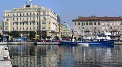
If you need to make a stopover you will find a temporary location in the basin "Gradska Luka", the city port used by cargo vessels, ferries and fishing boats. If you want to visit Rijeka or running errands, you must leave your boat at  Opatija marina.
Approach: no danger. Strong winds from S or rough seas can make the approach and entry difficult.
We moored alongside the wharf at E Gradska Luka.

The harbor is on the platform E, near the roots of the main breakwater. Customs are on the same platform.
Tel:  385 51 351 111
The harbor is on the platform E, near the roots of the main breakwater. Customs are on the same platform.

2011/03/27
Update
Joëlle
Luka Rijeka
2011-03-27
Update
Anonymous
Rijeka est la plus grande ville croate de la côte Adriatique.
Le port de commerce est divisé en plusieurs bassins.
Les plaisanciers ne sont pas les bienvenus à Rijeka bien que ce soit un port d'entrée. Il n'y a aucun équipement pour la plaisance.
Si vous devez y faire une escale vous trouverez un emplacement temporaire dans le bassin de "Gradska Luka", le port de la ville utilisé par les cargos, ferries et bateaux de pêche. Si vous souhaitez visiter Rijeka ou y faire des courses, vous devrez laisser votre bateau à Opatija marina.

Approche: aucun danger. Les vents forts de S ou une mer forte peut rendre l'approche et l'entrée difficile.

On s'amarre le long du quai à l'E de Gradska Luka .

La capitainerie est sur le quai E, près de l'enracinement du brise-lames principal. Les douanes sont sur le même quai.

Tel:  385 51 351 111
2011/03/27
Update
Joëlle
Luka Rijeka
2011-03-27
Update
Anonymous
Ebook

Kvarner

  • 120 sites
  • 182 photos
  • publication date: 8 Aug 2024
  • .pdf file size: 72 Mb
Ebook

Šibensko-kninska županija (Šibenik-Knin County)

  • 101 sites
  • 188 photos
  • publication date: 8 Aug 2024
  • .pdf file size: 65 Mb
Share your comments or photos on "Luka Rijeka"

Sites around Luka Rijeka

Flying distances - Direct line

Kanal Vela Vrata

13nm
214°
Kanal Vela Vrata connects the N end of Kvarner to Rijecki Zaliv and leads between the N end of Otok Cres, on the E side, and the mainland coast, on the W side.
The channel is deep and clear, the bottom being formed of mud.
31 Jul 11
Jojo

Tihi kanal

7.9nm
126°
Tihi Kanal, 3 miles long, connects the NW end of Vinodolski Kanal to Rijecki Zaliv.
The channel is deep and tortuous and leads between the mainland and the NE end of Otok Krk.
2 Aug 11
Jojo

Bakarski Zaljev Rijeka

5.3nm
111°
Bakarski Zaljev is a bayalmost closed on the continent, and SE of Rijeca N O. Krk. It is entered 6 NM ESE of Rijeka and is accessible by a channel of 0.3 nm wide at its narrowest point.
It is equipped with facilities for cargo.
There is a shipyard in Kraljevica, an oil terminal ...
31 Jul 11
Jojo

Otok Plavnik Kvarner

22nm
169°
Otok Plavnik lies with Rt Veli Pin, its N extremity, located 0.7 mile E of the E side of Otok Cres and divides Srednja Vrata in its S part into two channels.
This cliffy island is 194m high and partly wooded.
Several small islets lie on a shoal bank which extends about 1.5 miles ...
4 Aug 11
Jojo

Kanal Krusija

21nm
170°
Kanal Krusija leads to the W of Otok Plavnik.
This channel is frequented because of its steep-to shores and deep passage.
A strong current may occasionally be experienced in this channel, depending on local weather conditions, but this passage is recommended over the one leading ...
4 Aug 11
Jojo

Zaljev Rasa

25nm
218°
The large natural inlet Zaljev Rasa offers the best protection of all sectors of the entire E coast of Istria, while the Bora blows strongly here. This bay is sinking into the earth near 6M, between Rt Ubac and Rt Mulac. The Rijeka Rasa flows into the bottom, creating a current that ...
5 Sep 11
Jojo