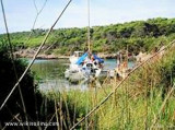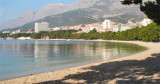

Uvala Donja Luka Makarska
0.3nm
304°
Beware of large unlit buoys marking the swimming area around the bay.
Anchor by 6 to 20 m.
2 Jun 11
Jojo
| Latitude | Longitude | |
| DMS | --- | --- |
| DM | --- | --- |
| DD | --- | --- |


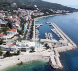
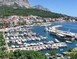
 The largest city of Makarska Riviera is the city that gave its name to the stretch of coastline from Grac up Brela and Riviera itself: Makarska.
 La plus grande
ville de la riviera de Makarska est la ville
qui a donné son nom à la partie du littoral allant de Grac jusqu'à Brela et à
la riviera elle-même: Makarska.
La plus grande
ville de la riviera de Makarska est la ville
qui a donné son nom à la partie du littoral allant de Grac jusqu'à Brela et à
la riviera elle-même: Makarska.On entre dans le port naturel entre deux caps rocheux séparés d'à peine 0,2 NM.
Il est bien abrité mais le ressac causé par le Ferry et les bateaux d'excursion n'est pas très agréable.
La ville de Makarska est remarquable du large. Le phare de Rt Sv. Petar, la pointe NW de Poluotok SV Petar et l'antenne satellite sur Rt Osejava au S permettent d'identifier l'entrée du port.
L'entrée est bordée de chaque côté de falaises rouges.
A environ 1,5 NM au SW de l'entrée, il y a une bouée sans feu indiquant l'extrémité d'un câble sous-marin.
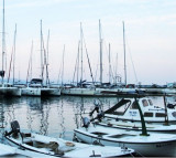
On s'amarre au quai en évitant le poste d'amarrage du Ferry. On peut aussi aller au Yacht-club au NW du port.
On peut aussi mouiller dans la partie SE du port par 5 m, en portant une amarre à terre en cas de Bora.
Bonne protection sauf du SW.

Ebook | Splitsko-dalmatinska županija (Split-Dalmatia Coun
|
Ebook | Dalmacija (Dalmatie)
|