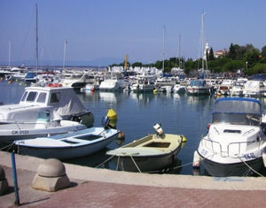
Luka Crikvenica

Luka Crikvenica

To precisely geolocate this site. Update if necessary.

Localisation

Characteristics

Port centre de plongée
Water sur brise-lames principal
Phone
Fuel à l'E près de la rivière
First aid
Shipyard 2 T. au nouveau port
Slip au nouveau port
Restaurant
Diving centre de plongée

Description

Luka Crikvenica
2008-07-11
Update
Ebook

Kvarner

  • 120 sites
  • 182 photos
  • publication date: 7 Jul 2023
  • .pdf file size: 69 Mb
Small busy port. A second port was created for the local boats to the E, just after the River. The fuel station is in between the W of the mouth.
Warning: shoals along the coast of the mainland on both sides of Crikvenica. 2 red buoys indicate the cylindrical end of the bench at NW of the port, and a green buoy marks the end of shoals SE.
To access the main port, it will pass between the red buoy over S and the breakwater at Port S. None of these buoys have fire, you must be very careful at night.
To reach the fuel station, go to the S of the green buoy.
The funds are from 5 m at the main port and 4m to the position of fuel.
There are three possibilities Location:
   Main port: mooring after the location of the Ferry, in the space reserved for visitors. Fund 3 m. Must be declared upon arrival at the Tourist Office that manages these sites, and levy a port.
   At the entrance of the river just outside the entrance of the river in good weather. Funds between 4 m and 2 m. Beware of submerged rocks in front of the end of the dike S.
   New port: the rock breakwater that protects the harbor of S. 3m cash inside. Protected harbor of S.
2011/07/29
Update
Jojo
Petit port très actif. Un deuxième port a été créé pour les embarcations locales à l'E, juste après la rivière. Le poste de carburant est entre les deux, à l'W de l'embouchure.
Attention: des hauts-fonds bordent la côte du continent de part et d'autre de Crikvenica. 2 bouées cylindriques rouges signalent l'extrèmité du banc au NW du port, et une bouée verte marque la fin des hauts-fonds au SE.
Pour accéder au port principal, on passera entre la bouée rouge la plus au S et le brise-lames du port au S. Aucune de ces bouées n'ayant de feu, il faut être très attentif de nuit.
Pour rejoindre le poste de carburant, passer au S de la bouée verte.
Les fonds sont de 5 m au niveau du port principal et de 4m au poste de carburant.
Il y a 3 possibilités d'amarrage:
  • Port Principal: amarrage après l'emplacement du Ferry, dans l'espace réservé aux visiteurs. Fonds de 3 m. Il faut déclarer son arrivée à l'Office de Tourisme qui gère ces emplacements et qui perçoit un droit de port.
  • A l'entrée de la rivière: juste devant l'entrée de la rivière, par beau temps. Fonds entre 4 m et 2 m. Attention aux roches submergées en avant de l'extrémité de la digue S.
  • Nouveau port: sur le brise-lames en enrochement qui protège du S le petit port. 3m de fonds à l'intérieur. Port protégé du S.
2011/07/29
Update
Jojo
Share your comments or photos on "Luka Crikvenica"

Sites around Luka Crikvenica

Flying distances - Direct line

Kanal Vela Vrata

18nm
264°
Kanal Vela Vrata connects the N end of Kvarner to Rijecki Zaliv and leads between the N end of Otok Cres, on the E side, and the mainland coast, on the W side.
The channel is deep and clear, the bottom being formed of mud.
31 Jul 11
Jojo

Tihi kanal

6.2nm
316°
Tihi Kanal, 3 miles long, connects the NW end of Vinodolski Kanal to Rijecki Zaliv.
The channel is deep and tortuous and leads between the mainland and the NE end of Otok Krk.
2 Aug 11
Jojo

Otok Plavnik Kvarner

14nm
208°
Otok Plavnik lies with Rt Veli Pin, its N extremity, located 0.7 mile E of the E side of Otok Cres and divides Srednja Vrata in its S part into two channels.
This cliffy island is 194m high and partly wooded.
Several small islets lie on a shoal bank which extends about 1.5 miles ...
4 Aug 11
Jojo

Rapski Kanal

19nm
169°
Rapski Kanal is deep and leads between Otok Sveti Grgur and Otok Rab.
This channel is seldom used as the fairway is only 0.3 mile wide in places and several rocky patches lie adjacent to its S side.
4 Aug 11
Jojo

Zaljev Soline Krk

3.2nm
257°
Zaliv Soline, a nearly landlocked small bay, lies 1.5 miles WNW of Rt Silo and is entered through a narrow channel.
Although there are depths of 10 to 12m over a width of 100m in the entrance, the bay has depths of only 2 to 4m and is used mostly by small craft.
1 Aug 11
Jojo

Kanal Krusija

14nm
209°
Kanal Krusija leads to the W of Otok Plavnik.
This channel is frequented because of its steep-to shores and deep passage.
A strong current may occasionally be experienced in this channel, depending on local weather conditions, but this passage is recommended over the one leading ...
4 Aug 11
Jojo