The Los Monjes islands, a federal dependency of Venezuela, are located to the northwest of the gul of Venezuela.
The islands consist of rocks rising steeply out of the sea, without any beaches or natural landing. The Venezuelan Navy maintains a base on El Sur, where it constructed a pier. The islands have no natural resources and must be supplied from the mainland. Fishing is the main activity around the islands, usually by fishing boats making the short trip from the Paraguaná Peninsula in Venezuela.
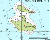
There are three islands or island groups, with a total area of 0.2 km²:
Monjes del Sur consists of the two largest islands, connected by an artificial dam. The southern of the two islands reaches a height of 70 m and has a lighthouse.
Monje del Este, a small rock 5.3 km northeast of Monjes del Sur, reaches a height of 43 m.
Monjes del Norte, is 12.3 km NNE of Monjes del Este, and consists of five small rocks, the largest one of which reaches a height of 41 m.
2016/01/1
Update
Joëlle
Share your comments or photos on "Los Monjes archipelago (Venezuela)"
The anchorage (12°21.45'N,
70°54.18'W) is on the southwest side of Isla Monje del
Sur. You moor to a two-inch polyester line attached to the
sides of an artificially created bay with room for five or
six boats. Unless you are absolutely certain the wind will
stay north ...
Water depth: 12 to 16 feet Yacht maintenance and repair Dive tank refills
Phone
Water Electricity (50Hz)
127-130V 30A
230 -240V 50A Gasoline and diesel fuel and bunker fuel available


 The Los Monjes islands, a federal dependency of Venezuela, are located to the northwest of the gul of Venezuela.
