Paarden Baai - (oranjestad)

Paarden Baai - (oranjestad)

To precisely geolocate this site. Update if necessary.

Localisation

Paarden Baai - (oranjestad)
LatitudeLongitude
DMS------
DM------
DD------

Characteristics

Port
Water
Fuel
First aid
Shipyard

Description

Small port.
2011/05/3
Update
Anonymous
Petit port .
2011/05/3
Update
Anonymous
Share your comments or photos on "Paarden Baai - (oranjestad)"

Sites around Paarden Baai - (oranjestad)

Flying distances - Direct line

Isla Los Monjes del Sur (Venezuela)

51nm
259°
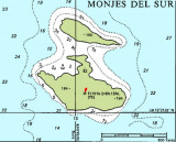
The anchorage (12°21.45'N, 70°54.18'W) is on the southwest side of Isla Monje del Sur. You moor to a two-inch polyester line attached to the sides of an artificially created bay with room for five or six boats. Unless you are absolutely certain the wind will stay north ...
1 Jan 16
Joëlle

Harbour Village

104nm
101°
Water depth: 12 to 16 feet  Yacht maintenance and repair  Dive tank refills Phone Water  Electricity (50Hz) 127-130V 30A 230 -240V 50A  Gasoline and diesel fuel and bunker fuel available
6 Mar 15
Joëlle