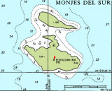
The anchorage (12°21.45'N,
70°54.18'W) is on the southwest side of Isla Monje del
Sur. You moor to a two-inch polyester line attached to the
sides of an artificially created bay with room for five or
six boats. Unless you are absolutely certain the wind will
stay north ...
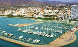
Located on the north coast of Colombia, Santa Marta was one of the
first cities to be discovered in the country and is also known as
"Ciudad Mágica" (the Magic City). Marina Santa Marta now has authorisation to act as a clearance agent. The marina will organise all clearance ...
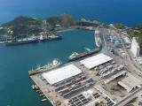
The port is a container terminal with no facilities for passengers. A short shuttle will bring you to the center of town by the beach next to the old Custom House. It's a port of call.


 Port.
Port. Port.
Port.