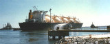
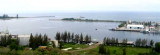
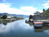
Lhokseumawe consists of several differents harbors and loading areas: from W to E there are Kruenggeukueh, Blanglancang (Arun), Ug Hago Oil Terminal, and the Old Lhokseumawe Harbor.
Tides—Currents.—The range of the tide is 2.1m. Strong crossing currents towards the SE have been reported at the mouth of the breakwater at Blanglancang Harbor.
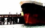
Pilotage.—Pilotage is compulsory for vessels over 88 grt and is available 24 hours. Requests for a pilot should be sent 6 hours before arrival and 3 hours before departure.
The vessel’s ETA should be sent 72 hours, 48 hours, and 24 hours in advance through Jakarta and Lhokseumawe. Vessels carrying LNG should send their ETA 96 hours, 48 hours, 24 hours, and 5 hours in advance. Contact the terminal directly when within VHF range, giving the precise ETA.
Several pilot boarding stations are reported below, as follows:
1. For Lhokseumawe Harbor and Ug Hago Oil Terminal—in the anchorage area.
2. For Blanglancang Harbor—at the Sea Buoy or in the LNG and Condensate Waiting Anchorages.
3. For Kruenggeukueh Harbor—in the anchorage area or 1 mile from harbor entrance at the breakwaters.
Caution.—Numerous bamboo poles, that are secured by long lengths of rope, used for marking fish pots, may be encountered within about 3 miles of the shore between Teluk Lhokseumawe and Tanjung Jambuair.
It is strongly recommended that ships give a wide berth to the reefs between Teluk Lhokseumawe and Tanjung Jambuair, as there is a constant W set.
Lhokseumawe extends up to 0.2 mile seaward of its charted position. Shallower depths than charted extend up to 1 mile offshore from Lhokseumawe to a position about 10 miles NW.
It has been reported (1993) that the limiting depth at the LNG and LPG facilities is 13.7m.
Significant ground swells originating in the Andaman Sea periodically effect sea conditions in the vicinity of Lhokseumawe
From Lhokseumawe to Tanjung Jambuair the coast is fringed by a sand bank, with depths of less than 5.5m, extending about 1 mile offshore, except off Krueng Piada about 10 miles E of Lhokseumawe, where it extends about 3 miles.Lhokseumawe port is situated on the N coast of Sumatra on the strait of Malacca.