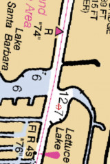
Formerly known as Lettuce Lake, this lake is part of the Intracoastal Waterway in Pompano Beach. It was originally named for the pond-like vegetation that formed on the surface of the lake.
The anchorage is located on the ICW's western shores, south of unlighted daybeacon #74. Minimum depth: 6' Good shelter
2010/05/1
Update
Joëlle
A popular free sheltered anchorage for transient cruisers that is set well back from the ICW and only 3 miles from Hillsboro Inlet. It is not well known that just beyond the 12" fixed bridge on US1 is boat accessible Pompano Market with groceries, resturaunts, and many stores.
Not a hospitable area for transient boaters. Be very careful where you leave a dingy etc. if going ashore.
2015/12/12
Update
Anciennement connu sous le nom de lettuce Lake, ce lac fait partie de l'Intracoastal Waterway à Pompano Beach. Il s'appelait à l'origine "Lettuce" à cause de la végétation qui recouvrait la surface du lac.
Le mouillage est situé sur la rive occidentale du ICW, au sud de balise non lumineuse # 74. Profondeur minimum: 1,8 m Bon abri
Located on the cove-like body of water along the Waterway?s eastern banks between unlighted daybeacon #74 and flashing daybeacon #76.. We anchore in 7' minimum depth. Good shelter.
Miami Beach occupies the barrier beach that separates the ocean from the upper part of Biscayne Bay and is also an important yachting center. A number of causeways, with bridges over the channels, form good highway connections with Miami and the mainland communities. The city is ...
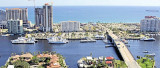
The Las Olas Docks facility is conveniently located on the Intracoastal Waterway and only steps from the breathtaking and newly revitalized beach. Completely renovated in 1998, the facility features a marina designed primarily for large vessels and offers ...
Situated half a block from the blue Atlantic, on the Intracoastal Waterway at Channel Marker 11, just one mile North of the Port Everglades Inlet.Tel: (954) 764-3975 Fax: (954) 779-3658 Mail: hfmarina@bellsouth.netSouth Dock Accommodates 20 Yachts up to 70' North ...
Just across a private walkway from the beach, Bahia Mar Beach Resort & Yachting Center is in the heart of Fort Lauderdale, 2 blocks from the shopping, dining, and nightlife of Las Olas Boulevard and 1 mile from Port Everglades.Tel: (954) 764-2233 250 slips Minimum depth: 10'
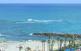
Boca Raton inlet is a narrow dredged cut through the beach 5 miles northward of Hillsboro Inlet Light. It is used mostly by party fishermen. The hotel at Boca Raton is a prominent landmark. The mouth of the inlet is protected by short jetties marked by private lights. In May ...


 Formerly known as Lettuce Lake, this lake is part of the Intracoastal
 Anciennement connu sous le nom de lettuce Lake, ce lac fait partie de l'Intracoastal
")