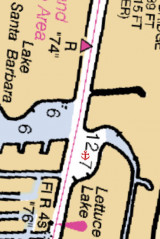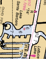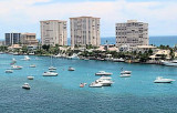

Boca Raton anchorage (Palm Beach)
0.6nm
351°
On the northeastern section of Lake
Boca Raton, south of flashing daybeacon #65, we can anchor 6 feet, but entrance channel can be tricky.
16 May 10
Joëlle
| Latitude | Longitude | |
| DMS | --- | --- |
| DM | --- | --- |
| DD | --- | --- |

 Boca Raton inlet is a narrow dredged cut through the beach 5 miles northward of Hillsboro Inlet Light. It is used mostly by party fishermen.
Boca Raton Inlet is dangerous and particularly hazardous to all boats not designed for open seas. Persons using this inlet should be experienced boatmen and should be extremely knowledgeable of the area. The channel is unmarked.
It is reported that shoaling exists
30 yards outside of the inlet and also inside the inlet. Depth at low tide varies from 1 to 3 feet. A sandbar protrudes out of water inside the inlet on the north side. A sandbar extends underwater to within 30 feet of the south jetty. Shoaling and sandbars are continually shifting.
It is further reported that increased shoaling may be expected and that the inlet may occasionally be closed by severe weather.
Tidal currents through the narrow channel reach a reported velocity of 7 knots.
It is further reported that except during a flat calm, breaking and confused seas exist at the mouth of the inlet.
Conditions worsen as seas and winds increase, particularly during ebb tide. Conditions are more hazardous during winter. Strong easterly winds are often encountered when attempting to navigate the inlet. These are particularly strong in November through May. In May through September heavy thunder storms often occur during early morning and afternoon.
")
 L'entrée de Boca Raton est une coupe étroite de la plage, draguée, à 5 M au N du feu d'entrée d'Hillsboro. Elle est principalement utilisée par les pêcheurs.
L'entrée a une profondeur de 30 m, mais elle diminue ensuite et varie de 0,3 m à 0,9 m à marée basse. Attention au banc de sable qui s'étend à moins de 9 m de la jetée S. La diminution de la profondeur et l'étendue des bancs de sable changent constamment.
Lors de phénomènes météorologiques violents, l'entrée peut être fermée à cause de l'accroissement de la sédimentation.
Les courants de marée dans le chenal étroit peuvent atteindre une vitesse de 7 n?uds.
Il est en outre signalé que, sauf par calme plat, la mer est agitée dans la bouche de l'entrée.
Les conditions se détériorent quand les vents soufflent fort, en particulier pendant la marée descendante.
Les conditions sont plus dangereuses en hiver. On y rencontre souvent de forts vents d'E dans l'entrée. Ils sont particulièrement forts de novembre à mai. De mai à septembre on assiste à de gros orages souvent tôt le matin et l'après-midi.
Ebook | US - East coast
|