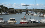
The old port, is situated on the S side of the
city at the head of an inlet. It is one of the largest coastal and
deep-sea fishing ports in France and is equipped to process fish
in considerable amounts.
The main harbor comprises of a tidal basin, an outer wet basin,
and inner wet basin. In addition, an extensive yacht marina
is situated on the S side of the harbor entrance.
The tidal basin has an entrance 25m wide. It dries in places
and is used by yachts and pleasure craft. The inner wet dock
has an entrance 10.2m wide. It is maintained at a depth of 3m
and is used mostly by yachts and pleasure craft up to 35m in
length and 9m beam.
The outer wet dock has an entrance 16.3m wide. It is maintained
at a depth of 4.3m and mostly used by fishing vessels up
to 100m in length and 14m beam.
2013/03/17
Update
pre
2013-03-17
Update
pre
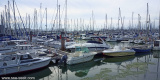
Le Vieux-Port de La Rochelle est le port historique de la ville. Les deux tours médiévales qui en gardent l'entrée l'ont rendu mondialement célèbre. 320 places dont 70 visiteurs
2019/07/4
Update
azerty
2021-07-16
Update
azerty
Bureau du Port
2021-07-16
Update
azerty
2021-07-16
Update
azerty
Share your comments or photos on "La Rochelle - Vieux port"
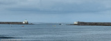
Access channel dredged to the coast -1. The axis of the channel is materialized, day and night, by the alignment at 059 ° of the two headlights: octagonal white with green top for the rear (23 m) and cylindrical with red and white bands and red top for the previous (14 m). The channel ...
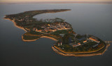
Connue pour être l'une des plus petites communes de France (257 électeurs) et la plus méridionale des Iles du Ponant, l'Ile d'Aix présente la forme d'un croissant de verdure et de sable au relief peu accentué, qui s'étend sur 130 hectares bordés de plages, de criques et de ...
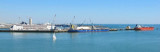
The port of La Pallice is situated on the E side of Coureau de la Pallice, the channel which separates Ile de Re
from the mainland. It is the only harbor between La Loire and
La Gironde which can accommodate large vessels. The principal
approach is through Pertuis d’Antioche but ...


 Canal 9


 The old port, is situated on the S side of the
city at the head of an inlet. It is one of the largest coastal and
deep-sea fishing ports in France and is equipped to process fish
in considerable amounts.
The main harbor comprises of a tidal basin, an outer wet basin,
and inner wet basin. In addition, an extensive yacht marina
is situated on the S side of the harbor entrance.
The old port, is situated on the S side of the
city at the head of an inlet. It is one of the largest coastal and
deep-sea fishing ports in France and is equipped to process fish
in considerable amounts.
The main harbor comprises of a tidal basin, an outer wet basin,
and inner wet basin. In addition, an extensive yacht marina
is situated on the S side of the harbor entrance. 
 Le Vieux-Port de La Rochelle est le port historique de la ville. Les deux tours médiévales qui en gardent l'entrée l'ont rendu mondialement célèbre.