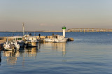
This port has 105 berths in its inner zone. It is distinguished by its pier of 200m long, surmounted by its beautiful green lighthouse 9m high. It offers mooring opportunities in the SE section and on the mooring in the NW.
tel / fax: 05 46 09 67 66
port .: 06 20 66 85 76
email: portlaflotte@orange.fr
2019/07/5
Update
azerty
Ce port dispose de 105 places dans sa partie intérieure. Il se distingue par son môle de 200m de long, surmonté de son joli phare vert de 9m de haut. Il offre des possibilités de mouillage sur filière dans sa partie SE et sur corps-morts dans le NW.
tel/fax: 05 46 09 67 66
port.: 06 20 66 85 76
email : portlaflotte@orange.fr
2013/03/17
Update
pre
La Flotte en Ré
Juillet 2021
2021-07-16
Update
azerty
Share your comments or photos on "La Flotte en Ré"
St. Martin de Ré is a small harbor. It is protected by breakwaters
and consists of two tidal basins and a wet dock. A narrow
entrance channel, which dries, leads between rocky flats
and is indicated by a range. Tides off the entrance rise about
6.1m at springs and 4.7m at neaps. ...
La création de ce port fut décidé en 1562. En 1845 qu’une digue fut ajoutée afin de protéger les embarcations des vents d’Ouest et plus principalement de la houle. 18 places en bassin d'échouage25 places en filière
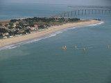
Très joli mouillage par vent de N NE NO et O sur fond de sable de très bonne tenu. Plage en pente douce, ne pas trop s’approcher... attention quelque fois, a la basse mer en cas de forte houle du large, cela déferle. Il y a 6 ou 8 bouées Départementales gratuites.
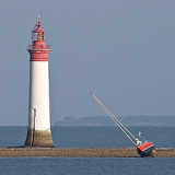
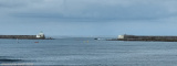
Pointe de Chauveau is at the SE extremity
of Ile de Re. A light is shown from a
prominent tower, 31m high, standing on the S edge of this
ledge and beacons are situated close E and 0.5 mile W of it.
The roadstead of Rade de la Pallice lies ENE of this point.Plateau de Chauveau, ...
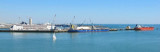
The port of La Pallice is situated on the E side of Coureau de la Pallice, the channel which separates Ile de Re
from the mainland. It is the only harbor between La Loire and
La Gironde which can accommodate large vessels. The principal
approach is through Pertuis d’Antioche but ...


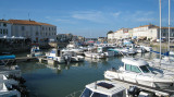


 This port has 105 berths in its inner zone. It is distinguished by its pier of 200m long, surmounted by its beautiful green lighthouse 9m high. It offers mooring opportunities in the SE section and on the mooring in the NW.
 Ce port dispose de 105 places dans sa partie intérieure. Il se distingue par son môle de 200m de long, surmonté de son joli phare vert de 9m de haut. Il offre des possibilités de mouillage sur filière dans sa partie SE et sur corps-morts dans le NW.