Kvarner

Kvarner

To precisely geolocate this site. Update if necessary.

Localisation

Kvarner
LatitudeLongitude
DMS------
DM------
DD------

Characteristics

Coast

Description

Kvarner
Le Kvarner (Le Quarner)
2008-07-06
Update
Kvarner
Le Kvarner (Le Quarner)
Vue du golfe de Kvarner
2008-09-20
Update
The Kvarner Gulf is located between Dalmatia and Istria. The mountain of Velebit and mountain Ucka contain this region of the cold north winds, and provide him a very pleasant climate in summer.
Opatija is the tourist capital, the resort of the Austro-Hungarian aristocracy and the Viennese court in the nineteenth century.

The northern coasts of the islands are often stripped and flogged by the Bora, while the southern shores are covered with lush Mediterranean vegetation.

You can find here some of the biggest Croatian islands: Krk, Cres, Rab and Losinj Pag, who have a special charm to many small fortified villages and fishing villages in small ports around beautiful pebble beaches white.

There are also smaller islands, like Susak, Ilovik, Premuda, Silba, Olib Ist, Molat and others. The coastline and some of these islands are equipped with spacious and modern marinas, such as those in Icici Opatija near or on the island of Cres and Punat on the island of Krk ...
The channels between these islands form the usual water route that connects north and south of the Adriatic, which is full of sailboats and yachts to or from the south.
The coast is graced with many bays and anchorages, boaters who amaze. Just pronounce the names Punta Kriza has Artatore, Ilovik, Krijal, Brgujski Zaljev, and we have before our eyes the image of a series of pleasure boats in a safe haven. If you sail in the channel at the foot of Mount Velebit, the contrast is striking. A coast almost completely stripped down steeply into the sea, leaving boaters some bays, coves and bays and isolated attractive as Zavratnica.

The port of Rijeka and its extensions in E (Susak, Martinscica, and Urinj Bakar) are all the more important port of Croatia.
Warning: a submarine cable crossing the Rt Sveti Andrija between Kvarner and Luka Cres.
Any underwater activity is prohibited in an area between the parallels of Ruth and Ruth Marler Seka, and extending from the coast to the meridian 14 ° 07 ° East.

WINDS:

The Bora (Bura) NE wind is sometimes very violent and dangerous in the Kvarner. She underwent significant changes in direction:
   * in the N, it usually blows in the channel axis.
   * In the central part, she turns to the east.
   * S in the part, she turns back to N.
The Sirocco wind from the SE, which blows mainly from October to April, is less common than the Bora. It produces a heavy sea, and in cold weather, accompanied by rain.
SE winds are usually of short duration. They often blow in gusts and still raise a heavy sea in the N Kvarner, they turn the S.

2011/07/29
Update
Jojo
Le golfe de Kvarner est situé entre la Dalmatie et l'Istrie. Le massif montagneux de Velebit et la montagne d'Ucka abritent cette région des vents froids du nord, et lui procurent un climat très agréable en été.
La capitale touristique est Opatija, lieu de villégiature de l'aristocratie austro-hongroise et de la cour viennoise au XIXe siècle.

Les côtes nord des îles sont souvent dénudées et fouettées par la bora, tandis que les côtes sud sont couvertes d'une végétation méditerranéenne verdoyante.

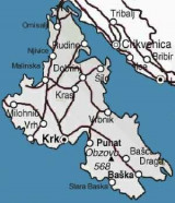
On trouve ici quelques unes des plus grandes îles croates : Krk, Cres, Rab, Pag et Losinj, qui ont un charme particulier grâce à de nombreuses petites bourgades fortifiées et aux villages de pêcheurs situés dans de petits ports, autour de belles plages de galets blancs.

On y trouve aussi des îles plus petites, comme Susak, Ilovik, Premuda, Silba, Olib, Ist, Molat et autres.
Le littoral et certaines de ces îles sont dotés de marinas spacieuses et modernes, comme celles à Icici près d'Opatija ou sur l'île de Cres et à Punat sur l'île de Krk...

Les canaux entre ces îles forment l'itinéraire nautique habituel qui relie le nord et le sud de l'Adriatique, qui est plein de voiliers et de yachts en direction ou en provenance du sud.
La côte est ornée de nombreux golfes et mouillages, qui émerveilleront les plaisanciers. Il suffit de prononcer les noms Punta Kriza, Artatore, Ilovik, Krijal, Brgujski, zaljev, et on a devant les yeux l'image d'une série de bateaux de plaisance dans un abri sûr.
Si l'on navigue dans le canal au pied du mont Velebit, le contraste est frappant. Une côte presque entièrement dénudée descend à pic dans la mer, laissant aux plaisanciers quelques baies, criques et golfes isolés et attractifs, comme Zavratnica.

Le port de Rijeka et ses extensions dans l'E (Susak, Martinscica, Urinj et Bakar) constituent l'ensemble portuaire le plus important de Croatie.

Attention: un câble sous-marin traverse le Kvarner entre Rt Sveti Andrija et Luka Cres.
Toute activité subaquatique est interdite dans une zone située entre les parallèles de Rt Marlera et de Rt Seka, et s'étendant depuis la côte jusqu'au méridien 14°07° Est.

VENTS


La Bora (Bura) vent du secteur NE, est parfois très violente et dangereuse dans le Kvarner. Elle y subit de notables changements de direction:
  • dans la partie N, elle souffle généralement dans l'axe du chenal.
  • dans la partie centrale, elle tourne à l'E.
  • dans la partie S, elle tourne de nouveau au N.

Le Sirocco, vent de secteur SE, qui souffle surtout d'octobre à avril, est moins fréquent que la Bora. Il produit une grosse mer et, dans la saison froide, s'accompagne de pluie.
Les vents de SE
sont en général de courte durée. Ils soufflent souvent par rafales et soulèvent toujours une grosse mer. Dans la partie
N du Kvarner, ils tournent au S. 
2011/09/5
Update
Jojo
Ebook

Kvarner

  • 120 sites
  • 182 photos
  • publication date: 7 Jul 2023
  • .pdf file size: 69 Mb
Share your comments or photos on "Kvarner "

Sites around Kvarner

Flying distances - Direct line

Otok Cres et Losinj Kvarner

6.7nm
183°
Otok Cres is 35 miles long and a chain of mountains extends along its entire length.
The E shore of the island, which is indented in the S part, forms the W side ofKvarneric. The W shore of the island forms the E side of Kvarner. Several villages are situated along its N part and ...
4 Aug 11
Jojo

Otok KrK Kvarner

13nm
Krk (i Italian Veglia, in Latin Curicta) is a Croatian island in the northern Adriatic Sea. It is located in the Rijecki Zaljev, between the mainland at E and to W Otok Cres.
With its 405 km ² (exactly 405 218 994 m², very slightly smaller than Cres), Krk is the second largest ...
2 Aug 11
Jojo

Rijecki Zaljev

23nm
340°
Rijecki Zaliv is an extensive basin in which several ports lie. It may be approached through three main channels and entered via three straits.
Kvarner, the W and widest channel, leads from the open Adriatic Sea end enters the basin via Kanal Vela Vrata.
Kvarneric, the middle ...
31 Jul 11
Jojo

Srednja Vrata

10nm
335°
Srednja Vrata leads between the NE part of Otok Cres and the W side of Otok Krk and connects
Kvarneric with Rijecki Zaliv.
4 Aug 11
Jojo

Otok Rab Kvarner

9.5nm
128°
The island of Rab is located in the Gulf of Kvarner between the island of Krk in the north-west and the island of Pag in the southeast.
It is traversed by a chain of hills. The summit of this island stands at the center of the NE side. It is 410m high and surmounted by a conspicuous ...
18 Sep 11
Jojo

Otok Susak

26nm
203°
Otok Susak is located about 5,5 NM at W from the S coast of O. Losinj.
Its extremities are fronted by shallow banks.

The top of the island has a lighthouse whose focus is 100 m above the level of the sea.
The village and port are located in Uvala Dragoca on the NE coast of the island.
31 Jul 11
Jojo