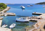
6NM long (NW/SE) Zut is the second island of Kornati. It is located NE of O. Kornat which protects it from onshore winds. There are no people except the people of Murter who come from time to time. The coast is steep and cut, there are beautiful bays such as Luka, Hiljaca, Saruscica, or Damn Bizikovac with mooring facilities for small boats and yachts seeking shelter during bad weather. Zut has a marina with 120 moorings.
2011/07/16
Update
Jojo
Otok Zut (Kornati)
2011-07-16
Update
Jojo
Longue de 6 M du NW au SE, Zut est la seconde île des Kornati. Elle est située au NE d'O. Kornat qui la protège des vents du large. Il n'y a pas d'habitants sauf les gens de Murter qui y viennent de temps en temps.
La côte est raide et découpée, on y trouve de belles baies telles que Luka, Hiljaca, Saruscica, Zut ou Bizikovac avec possibilité d'amarrage pour les petits bateaux et les voiliers qui cherchent un abri pendant le mauvais temps. Zut a une marina avec 120 amarrages.
Vrgadski Kanal, 7 miles long, leads between Otok Murter and Otok Vrgada and is the principal channel used in the S approach to Pasmanski Kanal and Zadar. Vessels with a maximum draft of 6.4m may pass through Pasmanski Kanal. Vessels with drafts over 6.4m must either proceed through ...
Otok Zirje
is the farthest and the largest island in the Sibenik archipelago. It is long of 6,5 NM (NW/SE) and 1,4 NM wide. The main village, Zirje, is located in the middle of the island. A small port, luka Muna, on the coast N of Zirje, home to the ferry that connects the ...
Kanal Nove Povljane, entered between Otok Vir and the SE end of Otok Pag, leads 5 miles SE into Ninski Zaliv. Shoals at the inner end of this channel restrict the fairway to a width of about 250m, with a controlling depth of 8m. Vessels with a draft of over 6m are advised not to ...
Novigradsko More, a landlocked bay, lies at the S end of Novsko Zdrilo and provides good anchorage. Rijeka Zrmanja flows into the bay at the E side. This river is navigable by small craft as far as the village of Obrovca, 6 miles above the mouth. Luka Novigrad, a narrow inlet, ...
Piškera (known as Jadra) is a small uninhabited island and one of the Kornati island. Its area is 2,66 km². Its coastline is 10,64 km long. It is just off the SW coast of O. Kornat, about 3 NM of Vrulje.There are two islands and some reefs on the S coast. O. Panitula Vela, the ...
Luka Hiljaca is located on the NE coast of O. Zut, SE from Luka Zut. The small island of Gustac protects it from the NE. As you approach the bay by SE, attention to the isolated Shoal under 3.3 m of water to about 0.3 NM SE of O Gustac, between the island and the rock et ...


")
 6NM long (NW/SE) Zut is the second island of Kornati. It is located NE of O. Kornat which protects it from onshore winds.
")
 Longue de 6 M du NW au SE, Zut est la seconde île des Kornati. Elle est située au NE d'O. Kornat qui la protège des vents du large.