Otok Zirje (Sibenik)
It is long of 6,5 NM (NW/SE) and 1,4 NM wide.
The main village, Zirje, is located in the middle of the island. A small port, luka Muna, on the coast N of Zirje, home to the ferry that connects the ...
| Latitude | Longitude | |
| DMS | --- | --- |
| DM | --- | --- |
| DD | --- | --- |

 The Kanal Sveti Anke is tortuos and narrow channel that leads to the city and the port of Sibenik.
A constant current sets outward through Kanal Sveti Ante at rates of 0.5 to 1.5 knots. After heavy rains, the velocity of this current may reach 3 knots and cause some rips.
Pass W to Rt Rocni. A buoy with a red light, at 0.5 NM S of Rt Jadrija indicates the end of a shoal (in less than 10 m) that extends to the Rt Jadrija S. Leave the buoy on the port side on reaching the entrance to the Ante Kanal Sv. Then the channel is simple to Sibenik.
At night the channel includes lights (red to port, green to starboard).
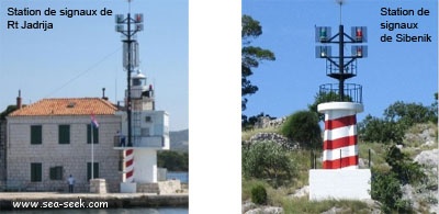
The passage of ships of more than 50 T is controlled by signals to the station signals of Rt Jadrija and at the fortress Sv Ana in Sibenik. Two black spheres, or two vertical green lights indicate that the channel is free. A red cone pointing down or two vertical red lights mean that there is a ship in the channel.
The speed limit is 6 knots.
E of Rt Jadrija, there are two bays where you can anchor. The coves on the S side of the channel are in a naval base.
Once through the canal Sv Ante, we arrive at Sibenik.
E of the exit channel a shoal (Plicina Paklena) beyond the shore of 0.1 NM and is marked by a fire. Pass widely N of the light.
SE of Sibenik are two bays, the largest, Uvala S. Petar, is prohibited.

 Le Kanal Sveti Anke est l'étroit chenal tortueux qui mène à la ville et au port de Sibenik.
Un courant constant, de 0,5 à 1,5 nœuds, provenant de l'extérieur circule dans le Kanal Sveti Ante . Après les fortes pluies, la vitesse de ce courant peut atteindre 3 nœuds et causer des dégâts.
Passer à l'W de Hr Rocni. Une bouée avec un feu rouge, à 0,5 NM au S de Rt Jadrija, indique l'extrémité d'un haut-fond (sous moins de 10 m) qui prolonge Rt Jadrija vers le S. Laisser la bouée sur bâbord en arrivant sur l'entrée du Kanal Sv Ante. Ensuite le chenal est simple jusqu'à Sibenik.
De nuit le canal comporte des feux (rouges à Bâbord, verts à Tribord).
Le passage des navires de plus de 50 T est régulé par des signaux à la station de signaux de Rt Jadrija et au fort de Sv Ana à Sibenik. Deux sphères noires ou deux feux verts verticaux indiquent que le chenal est libre. Un cône rouge pointe en bas ou deux feux rouges verticaux signifient qu'il y a un navire dans le chenal.
La vitesse est limitée à 6 nœuds.
A l'E de Rt Jadrija, se trouvent deux baies où l'on peut mouiller. Les criques sur la rive S du canal sont dans une base navale.
Une fois franchi le canal Sv Ante, on arrive à Sibenik.
A l'E de la sortie du canal un haut-fond (Plicina Paklena) déborde sur la rive sur 0,1 NM et est signalé par un feu. Passer au N de ce feu en lui donnant un large tour.
Au SE de Sibenik se trouvent deux baies dont la plus grande, Uvala S. Petar, est interdite.
Ebook | Šibensko-kninska županija (Šibenik-Knin County)
|
Ebook | Dalmacija (Dalmatie)
|


