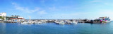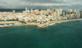

Ensenada de Benidorm (C Blanca)
1.5nm
42°
This bay affords ...
20 May 12
Jojo
| Latitude | Longitude | |
| DMS | --- | --- |
| DM | --- | --- |
| DD | --- | --- |


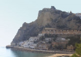
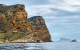
 In front of the bay of Denidorm, this small triangular island has a length of 350 m and 260 m wide.
 It is separated from the coast about 2.5 MN.
")
 Face à la baie de Denidorm, cette petite île triangulaire a une longueur de 350 m sur 260 m de large.
 Elle est séparée de la côte d'environ 2,5 MN.
L'île est une aire marine protégée.
C'est un lieu privilégié pour la plongée sous-marine en raison de la grande variété des écosystèmes présents.
Un haut-fond plat, de couleur blanchâtre et rocheux, à une profondeur minimale de 5,8 m, s'étend sur 200m dans une direction NNE à SSW et peut fournir un bon mouillage. Ce banc s'étend à 0,2 MN de l'île.
Un feu se trouve sur l'île en haut d'une tour de 4 m de haut.
")
")
Ebook | Espagne Est - East Spain
|