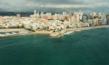
Ensenada de Benidorm lies between Cabezo del Tosal and Punta de la Escaleta, 3 miles E. the small hill Canfali, which forms a promontory in the center of the cove of Benidorm, divides the coast into two splendid sandy beaches, the Levant and the Ponant.
Algar de la Almadraba, centered about 6 miles NW of Denia, is an extensive area of foul ground which lies off this stretch of coast. This area has depths of 25 to 36m and heavy seas are raised over it by onshore winds.
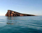
In front of the bay of Denidorm, this small triangular island has a length of 350 m and 260 m wide. It is cliffy, barren, and reddish.It is separated from the coast about 2.5 MN. The island is a marine protected area.
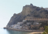
El Tossal de la Cala stands out for being a late Iberian settlement in the centuries 3 to 1 BC, used as a point of trade and for disembarking in ancient times. The site at the top of the hill is preserved.El Tosal point is the begining of Benidorm bay.
Punta de La Escaleta is is high (70 m), and carries a steep tower.
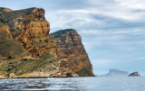
From this point, the chain of cliffs called "Sierra Helada" or "rocks Arabi" extends to the NE over a length of 3.5 NM. These reddish cliffs, which rise up to 190 m, are overlooking the sea and a gentle ...


 Canal 9


 The small harbour of Benidorm offers many nautic activities and an sailing school. It is designed for small boat.
 Le petit port de Benidorm offre de nombreuses activités nautiques et une école de voile. Il est conçu pour les petites structures.
")
")