The Isle of Man is located in the Irish Sea at the geographical centre of the British Isles. The head of state is Queen Elizabeth II, who holds the title of Lord of Mann. The Isle of Man is not a part of the European Union, but has a limited relationship relating to the free movement of goods.
2010/08/16
Update
Wikiadmin2
Isle of Man
2010-08-16
Update
Anonymous
L'île de Man est formé d'une île principale et de quelques îlots situés en mer d'Irlande, au centre des îles Britanniques. L'île de Man forme une dépendance de la Couronne britannique, c'est-à-dire que l'île n'appartient ni au Royaume-Uni ni à l'Union européenne mais relève directement de la propriété du souverain britannique, actuellement la reine Elizabeth II. Ce statut n'en fait toutefois pas un État reconnu indépendant mais celui-ci dispose d'une large autonomie politique et économique.
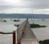
The inner harbour marina (accessible at approximately high water +/- 2 hours) is the main area for visiting leisure craft to berth but there are also berths in the outer harbour which are less dependent on the tides. A summer only pontoon is available for short periods at all states ...
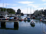
Castletown is a heritage harbour consisting of outer and inner drying harbours. It is mainly used by inshore fishing vessels, local and visiting pleasure craft and occasional coasters. Berths available Moorings: One white can type mooring buoy is situated 3 cables SE of the Breakwater ...


 The Isle of Man is located in the Irish Sea at the geographical centre of the British Isles.
 L'île de Man est formé d'une île principale et de quelques îlots situés en mer d'Irlande, au centre des îles Britanniques. L'île de Man forme une dépendance de la Couronne britannique, c'est-à-dire que l'île n'appartient ni au Royaume-Uni ni à l'Union européenne mais relève directement de la propriété du souverain britannique, actuellement la reine Elizabeth II. Ce statut n'en fait toutefois pas un État reconnu indépendant mais celui-ci dispose d'une large autonomie politique et économique.