Isla del Descubridor (Cap de La Nao)

Isla del Descubridor (Cap de La Nao)

To precisely geolocate this site. Update if necessary.

Localisation

Isla del Descubridor (Cap de La Nao)
LatitudeLongitude
DMS------
DM------
DD------

Characteristics

Island / Atoll
Diving

Description

Isla del Descubridor, 57m high, lies close offshore, 1 NM WSW of the cape.

It is a deep dive site, with slopes and rock formations that create refuge for a great variety of marine life.

The narrow channel lying between this island and the mainland cannot be used.

2012/05/14
Update
Jojo
Isla del Descubridor (57 m de haut) se situe tout près de la côte, à 1 MN à l'WSW du cap de La Nao.

C'est un site de plongée profonde, avec des pentes et des formations rocheuses qui créent d'excellents refuges pour une variété de vie marine.

L'étroit passage qui la sépare de la côte ne peut pas être utilisé.


2012/05/14
Update
Jojo
Isla del Descubridor (Cap de La Nao)
2012-05-14
Update
Jojo
Isla del Descubridor (Cap de La Nao)
2012-05-14
Update
Jojo
Ebook

Espagne Est - East Spain

  • 236 sites
  • 414 photos
  • publication date: 8 Aug 2024
  • .pdf file size: 192 Mb
Share your comments or photos on "Isla del Descubridor (Cap de La Nao)"

Sites around Isla del Descubridor (Cap de La Nao)

Flying distances - Direct line

Algar de Almadraba (C Valenciana)

13nm
313°
Algar de la Almadraba, centered about 6 miles NW of Denia, is an extensive area of foul ground which lies off this stretch of coast. This area has depths of 25 to 36m and heavy seas are raised over it by onshore winds.
23 May 12
Jojo

Ensenada de Javea (C Blanca)

3.2nm
349°
Beyond Cape San Martin extends the Javea cove to Cape San Antonio.
This cove is exposed to winds from SE and NE.

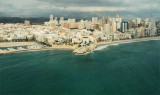
The town of Javea, located in the N of the loop is built on a hill at 0.8 NM from the shore. It overlooks the Rio Jalon or Gorgos that opens near and ...
22 May 12
Jojo

Ensenada de Benidorm (C Blanca)

19nm
230°
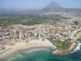
Ensenada de Benidorm lies between Cabezo del Tosal and Punta de la Escaleta, 3 miles E.  the small hill Canfali, which forms a promontory in the center of the cove of Benidorm, divides the coast into two splendid sandy beaches, the Levant and the Ponant.

This bay affords ...
20 May 12
Jojo

Ensenada del portichol (C Blanca)

1.8nm
21°
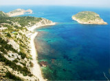
N Nao cape, Portichol bay opens between two projecting points, at S the Negro Cape and  San Martin Cape at N. The coast is steep and steep except for a small beach.

Front of the bay, the island of Portichol and a rock at his side ...
22 May 12
Jojo

Cabo de La Nao (Javea)

0.7nm
63°
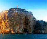
The Cabo de La Nao (100 m) is eastern tip of Alicante. It's the end of Vanence bay and a shift from the coast . It's located between N Costa del Azahar and S Costa Blanca.A light is shown from a tower with a dwelling, 20m high, standing on the cape. A radiobeacon is situated ...
22 May 12
Jojo