In N Tortosa Cape, the low and swampy coast of the delta of the Ebro is oriented NW, and before its junction with the mainland, a peninsula of sand is detached forming bays of the Ampolla and del Fangal.Ampolla bay lies between ...
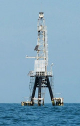
Cape Tortosa is the eastern end of the island Buda at the Ebro River delta. In the W Cape, at about 1 MN, stands a lighthouse, located on latitude 40 ° 42 and longitude 55 ° 0. This iron tower is 50 m high. It is not advisable to approach within 2 NM and one must be careful in ...
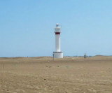
The sand peninsula, N Tortosa cape, has a lighthouse at its NW point, Punta del Fango. The lighthouse tower, 18 m high, is standing 1,5 NM E of the point.The point is extended to approximately 0.3 MN by a sandbar covered with 0.80 m of water.
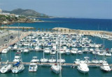
Calafat marina is located N Cabo San Jorge,
in the locality of Amettla del Mar, in the Gulf of San Jorge. T. 977486184 F. 977486023 M. info@portcalafat.com 404 b.(<25 m)
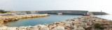
Ametla harbour is an authentic fishing port where auction sales are renowned for the quality of its products.
In the heart of the Costa Dorada, Ametlla is approximately 3 hours from the French border. Ametlla port is one of the most important of Catalonia, as much by the ...


 Buda island, very low and sometimes partially submerged, separates the two mouths of the Ebro, mouth S and mouth N (Golas N and S).
 L'île Buda, très basse et parfois submergée en partie, sépare les deux bouches de l'Ebre, la bouche S et la bouche N (Golas N et S).
")