Houlographe au large de Banyuls fournissant des mesures en temps réel de la houle. Extrait du site http://candhis.cetmef.developpement-durable.gouv.fr Meteo
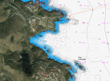
Cap l’Abeille is located 1.2 miles NNW of Cap Peyrefite. The coast between is high, rugged, and fronted by rocks. Tour de la Massane (elevation 808m) and Tour Madeloc (elevation 671m) and illuminated at night, both in ruins, stand on peaks 5.7 miles and 3.5 miles WNW, respectively, ...
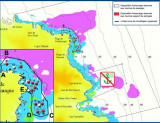
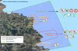
Réserve Marine La réserve est bornée par deux balises jaunes, facilement repérées entre le Cap Peyrefite et le Cap Bear, avant Banyuls. La réserve intégrale est quant à elle, localisée sur le Cap Rédéris. A cet endroit la nature y est sanctuarisée dans le but de ...
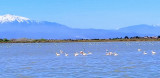
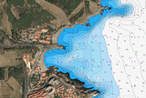
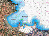
Baie de Banyuls lies between Cap Dosne and Ile Grosse, a rock, 0.2 mile ESE. Ile Grosse, 7m high, is joined to the mainland by moles and breakwaters. The bay is divided into two parts by Ile Petite, 3m high. Anse de la Ville, the W part, fronts the town of Banyuls-sur-Mer. Anse ...