Hoedic

Hoedic

To precisely geolocate this site. Update if necessary.

Localisation

Hoedic
LatitudeLongitude
DMS------
DM------
DD------

Characteristics

Island / Atoll

Description

A Hoëdic, il y a 2 ports le  "port de l'Argol" au nord ou le "port de la Croix" au sud.


Sinon, il y a quelques mouillages, sur la côte Est et Sud-Est, faut aimer le rase-cailloux pour y accéder, mais on y est vraiment très bien.
2013/01/5
Update
dd
Ebook

Golfe de Gascogne

  • 266 sites
  • 250 photos
  • publication date: 9 Jul 2023
  • .pdf file size: 204 Mb
Share your comments or photos on "Hoedic"

Sites around Hoedic

Flying distances - Direct line

Houat

4.7nm
301°
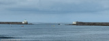
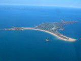
Island 31m high located 6.5 miles SE of Pointe du Conguel and surrounded by foul ground. The belfry of the church standing in the village of Port St. Gildas, at the NE end of the island, is prominent.
6 Jan 13
dd

Hoedic port de l'Argol

0.1nm
305°
Léger clapot par vent de Nord  Est  ?? en fait les bateaux amarrés sur la tonne N°1 dans la nuit du 13 au 14/08/2016 se sont littéralement sautés dessus de 23h00 jusqu'à 4 heures du matin  , pare battage arrachés , filières endommagées , impacts sur franc bord ...
19 Aug 16

Port de la Croix

0.5nm
197°
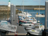
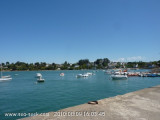
Port tout petit où ça échoue  mais c'est mignon . On peut également échouer sur la plage à proximité, attention il y a plein d'embarcations de pêche sur bouées juste devant.
5 Jan 13
dd

Ile aux Moines

14nm
Provide here details of the site. You can put text or images.
19 Sep 10

Treac'h Ar Goured

4.1nm
309°
Mouillage très fréquenté face à la grande plage de Treac'h er Goured, abritée des vents dominants de sud-ouest à nord-ouest.
5 Dec 07

Saint Gildas

4.5nm
310°
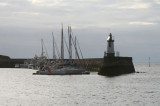
Small and shallow harbor, protected by a breakwater, in front of the village, used by fishing boats. The belfry of the church standing in the village of Port St. Gildas, at the NE end of the island, is prominent.  La Vieille, a rock 14m high, lies 0.7 mile NNE of the harbor, ...
6 Jan 13
dd