The Gulf of Guinea is the northeasternmost part of the tropical Atlantic Ocean from Cape Lopez in Gabon, north and west to Cape Palmas in Liberia. The intersection of the Equator and Prime Meridian (zero degrees latitude and longitude) is in the gulf. Among the many rivers that drain into the Gulf of Guinea are the Niger and the Volta. The coastline on the gulf includes the Bight of Benin and the Bight of Bonny.
2020/02/14
Update
Renée
Piracy in the Gulf of Guinea affects a number of countries . Pirates in the Gulf of Guinea are often part of heavily armed criminal enterprises, who employ violent methods to steal oil cargo.
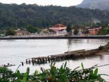
SÃO TOME & PRINCIPE, Un des plus petits Etats d'Afrique, surnommé "Îles du Milieu du Monde" mais aussi "Île Chocolat" car au début du siècle dernier, il fut le premier producteur mondial de cacao. Ancienne colonie portugaise, c'est un état indépendant depuis 1975.


 The Gulf of Guinea is the northeasternmost part of the tropical Atlantic Ocean from Cape Lopez in Gabon, north and west to Cape Palmas in Liberia. The intersection of the Equator and Prime Meridian (zero degrees latitude and longitude) is in the gulf.