Outer Mati Bank (3°28'N., 99°35'E.), about 15 miles long in a NW and SE direction, lies with its NW end about 11 miles NNW of Tanjung Tanjung. A depth of 8.2m lies near the center of the bank. Some discoloration exists over this bank when the current is strong.
An explosive dumping ground is situated approximately 5 miles NE of Outer Mati Bank.
Pulau Pandang and Pulau Salahnama, also known as The Brothers, are two rocky islands, 64m and 89m high, respectively, which stand about 17 miles ENE and 14 miles E of Tanjung Tanjung.
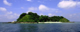
Pula Salahnama (3°20'N., 99°43'E.) is densely wooded;its rocky sides rise steeply from the sea. An above-water rocklies close N of the island and a similar rock lies about 0.5 mile S of the island. Anchorage can be taken about 1 mile from the NW and SE sides of Pulau Pandang ...
Pulau Pandang (3°25'N., 99°45'E.) is almost entirely surrounded by a coral reef with some above-water rocks. A foul area was reported to lie about 9 miles E of the island. A light is shown from Pulau Pandang.The island is hilly and covered with virgin
forest, nice for small ...
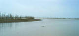
The river which flows into the strait at Tanjung Tanjung has a narrow entrance and shallow depths.
Tanjung Tanjung is low but can be identified by its white sandy beach and high trees. A strong current sometimes sets here along the coastal bank. Vessels when crossing the mouth ...
Between Tanjung Tanjung and Tanjung Tiram, about 9 miles SE, the coast is bordered by a white sandy beach except for a bank of mud and mangroves about 2 miles S of Tanjung Tanjung. A light is shown from Tanjung Tiram.
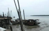
Tanjung Tambuntulang, about 11 miles ESE of Tanjung Tiram, is a low (3 m above sea level) overgrown point. The Sungai Tambuntulang discharges close W of the point and is marked by the village of the same name. Tambuntulang Bank, with depths of from 1.8 to 5.5m and fairly steep-to, ...
The Sungai Asahan is entered between Tanjung Napal, 10 miles SE of Tanjung Tambuntulang, and Tanjung Jumpul, about 2 miles to the SE. These points and the coast in the vicinity are low, muddy and overgrown with mangroves. The channel is marked by buoys and beacons. Jumpul ...


 Outer Mati Bank (3°28'N., 99°35'E.), about 15 miles long in a NW and SE direction, lies with its NW end about 11 miles NNW of Tanjung Tanjung. A depth of 8.2m lies near the center of the bank.