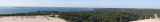

Saint Nazaire - Île d'Oleron
57nm
38°
7 Mar 13
dd
| Latitude | Longitude | |
| DMS | --- | --- |
| DM | --- | --- |
| DD | --- | --- |

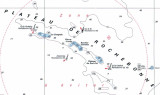
 The Bay of Biscay (name coming from the Castillan), called Golfe de
Gascogne by the French, is entered between Ile d’Ouessant and Cabo
Ortegal, 305 miles SW. The bay is bounded on its E side by the W coast
of France and on its S side by the N coast of Spain. It is generally
clear and deep throughout.
The Bay of Biscay (name coming from the Castillan), called Golfe de
Gascogne by the French, is entered between Ile d’Ouessant and Cabo
Ortegal, 305 miles SW. The bay is bounded on its E side by the W coast
of France and on its S side by the N coast of Spain. It is generally
clear and deep throughout.The W coast of France, between Ile d’Ouessant and the entrance of La Gironde, is much indented and bordered by numerous islands, rocks, and sand flats. Southward of La Gironde, as far as the Rio Bidasoa, which forms the boundary line between France and Spain, the coast is low and uniform, with sandy dunes, and generally clear of off-lying shoals. The principal rivers are the La Loire and the Garonne, with the latter known in its lower part as the La Gironde; the smaller ones are the Odet, the Vilaine, the Adour, and the Nive.
The most important islands, which lie principally off the NW part of the coast, are Ile d’Ouessant, Ile de Groix, Belle Ile, Ile d’Yeu, Ile de Re, and Ile d’Oleron.
 Le golfe de Gascogne s'étend de la Bretagne aux Pyrénées-Atlantiques. Il porte différent nom:
 Ebook | Golfe de Gascogne
|