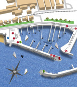
The port is composed of the old port at W and the Camille Rayon Port at the E. Both are accessible by the same entrance.
844 berths incl. 80 visit.
2012/03/28
Update
Le port est composé du vieux port de Golfe Juan à l'Ouest et du nouveau port Camille Rayon à l'Est. Les deux sont accessibles par la même passe d'entrée.
844 places (<75m) dont 80 visit.
tel 04 93 63 30 30
Fax 04 93 63 55 07
port@camillerayon.net
https://www.portcamillerayon.net/
2021/02/2
Update
Phil-de-TudoBem
un texte dfdfgdfgdf dfgdfg
2021/02/2
Update
moi
Share your comments or photos on "Golfe Juan - Port Camille Rayon"
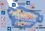
Ile Saint-Marquerite, the bigest island close to the city of Cannes, lies centered 1 mile SSE of Cap de la Croisette and is very wooded. A conspicuous citadel, in which there is a disused signal station, stands near the middle of the N coast of the island. A small shipyard is situated ...
Port de Golfe Juan, lying 2.5 miles NE of Cap de la Croisette, is a small craft harbor which is protected by two breakwaters and has extensive facilities for yachts. A light is shown from a white square tower with corbels, 16m high, standing 0.7 mile WNW of the harbor entrance. A ...
Golfe Juan is entered between Cap de la Croisette and Point de l'Ilette, 3.8 miles ENE. This gulf is sheltered from the SW by Iles de Lerins and from the S by shoals and is one of the best roadsteads along this part of the coast. In the approaches to the gulf, the currents are weak ...
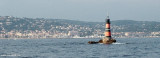
Le phare (rouge et noir) émerge au milieu de la baie de Golfe Juan pour signaler un récif dangereux à la navigation. Ce site offre de nombreuses possibilités à tous les plongeurs. Au pied du phare vous pourrez admirer les restes d'un village miniature qui était destiné ...
Port on the West side of the cap d'Antibes . The port entrance is marked by two lights (red-green). Facing S-S-W, its entrance opens to N-N-W assuring totally calm waters within the port which is completely protected from all winds. 524 berths incl. 50visit. Lenght maxi. 45 m
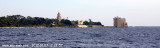
A conspicuous chateau stands on a projection on the S coast of the island. The belfry of an abbey, which emerges from the surrounding trees close N of the chateau, is prominent. The E extremity of the island is surrounded by small islets and rocks which extend up to 0.3 mile from ...


 canal 9


 Camille Rayon

 2006-10-08

 The port is composed of the old port at W and the Camille Rayon Port at the E. Both are accessible by the same entrance.
 Le port est composé du vieux port de Golfe Juan à l'Ouest et du nouveau port Camille Rayon à l'Est. Les deux sont accessibles par la même passe d'entrée.