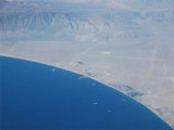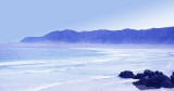

Bahia Nuestra Senora (Antofagasta N chile)
106nm
117°
27 Dec 12
Joëlle
| Latitude | Longitude | |
| DMS | --- | --- |
| DM | --- | --- |
| DD | --- | --- |

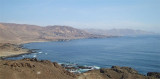
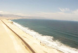
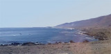
 Along this coast there are many large and small bays, many points. Many islets and rocks border the coast.
Generally, the sea fronting this coast is deep but there are many underwater hazards along this coast. Many benches, 2 NM off, often beyond they. We must be very careful because these hazards are not always on the charts.
The geographic positions given in this sector have been obtained from the latest available Chilean charts and may differ as much as 1.2 miles S, 3.5 miles N, or 2 miles E from their charted positions.
Antofagasta is the largest port in northern Chile. The ports of Arica, Iquique, Tocopilla, Taltal, Chanaral, Caldera, Huasco, and Coquimbo are important. In addition, there are a number of smaller roadsteads and ore-loading ports.
The principal points, islands, and harbors are lighted. Fog occurs along this coast at infrequent intervals.
The currents off the coast of Chile are influenced by the Peru Current (or Humboldt curant). In general, this fresh current sets N parallel to the coast at a velocity of 0.5 knot. It sets slightly stronger from May to October than from November to April. The current is generally stronger near the land than at sea.
 Le long de cette côte on trouvent de nombreuses grandes et petites baies, plusieurs pointes. De nombreux îlots et rochers bordent la côte.
En général, la profondeur est grande mais de nombreux dangers sous-marins bordent cette côte. De nombreux bancs, à 2 MN au large, débordent souvent celle-ci. Il faut être très prudent car ces dangers ne figurent pas toujours sur les cartes.
Les positions géographiques données dans ce secteur viennent de cartes chiliennes et diffèrent d'environ 1,2 MN au S et 2 MN à l'E des positions réelles. Des dangers non cartographiés peuvent exister.
Antofagasta est le plus grand port du N du Chili. Ceux d'Arica, Iquique, Tocopilla, Talfal, Chanaral, Caldera, Huasco et Coquimbo sont importants. On trouve aussi des petits ports de chargement de minerai.
Les principales pointes, îles et les principaux ports sont éclairés car le brouillard sévit le long de cette côte, à intervalle régulier.
Les courants chiliens sont influencés par le courant du Pérou (ou courant de Humboldt). En général ce courant frais vient du N, parallèle à la côte, à une vitesse de 0,5 noeuds. Il augmente plus fortement de Mai à Octobre et plus près des côtes qu'en pleine mer.
Ebook | Chile
|