This old port is at the W church, a Byzantin round roof visible from anywhere in the bay. This small port is on the right and side of commercial quay. 230 berths (<60m)
Prohibited areas, the limits of which are shown on the chart, lie SW of Pointe du Titan (Ile du Levant) and extend up to 2 miles from the coast. These areas, which are used by French naval vessels, are not in force between July 1 and August 31. Vessels are prohibited from approaching ...
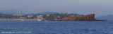
Lieu de plongée très connu. De très nombreuses plongées sont effectuées
autour de cet îlot rocheux. S'amarrer à la bouée le plus au sud pour
faire le tombant au sud du rocher. Faire le tour du tout petit rocher
sud et vous aurez fini la plongée de ce tombant. On peut ...
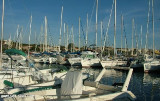
Large port with 2 basins N and S. Port sheltered from all winds, but care must be taken in very strong SE. Landmark: Le Lion de Mer, in front of the port, rock at 20 m aver the sea. 1542 berths
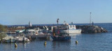
Port sheltered from Mistral wind and E wind swell. Danger: Sandbanks in the port passage when entering, marked by a conical yellow buoy, draught minimum 2 m. 239 B. (<15mx4,50m) inc. 2 visit. (1 of 10mx3,40m and 1 of 5,50mx2,15m)
Ne cherchez pas le nom d'Arminette sur les cartes actuelles (tant marines que terrestres), il n'y figure pas. On ne le trouve plus que dans les guides de croisière anciens. Guides, instructions nautiques et cartes d'aujourd'hui mentionnent le minuscule port de plaisance de Boulouris, ...


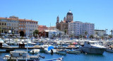


 Port-Frejus is located on an ancient Roman port called "Forum Jilii".
 Cette vaste marina a été construite dans les terrains plats de la plaine de l'Argens, sur les sites de l'ancien port romain de "Forum Jilii".
 Harbour entrance
 Quai carburant au NE en entrant.