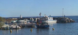
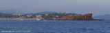
Large port with 2 basins N and S. Port sheltered from all winds, but care must be taken in very strong SE. Landmark: Le Lion de Mer, in front of the port, rock at 20 m aver the sea.
1542 berths
2012/01/7
Update
dd
Grand port au Sud Est de la ville, composé de deux bassins: N et S. Ce port est abrité de tous les vents, mais attention au très fort SE. Amer: îlot du Lion de Mer, face au port, gros rocher surplombant la mer de 20m.
1542 places
Tel. 04 94 95 34 30
F. 04 94 95 22 13
2007/11/24
Update
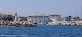
passe du bassin sud
2011/12/28
Update
mbringer
Entrée du bassin sud de la marina santa lucia, photo réalisée en novembre 2011.
2012/01/7
Update
dd
2011:10:11 15:27:59
2012-01-07
Update
mbringer
Share your comments or photos on "St Raphaël - Port Santa Lucia"
Lieu de plongée très connu. De très nombreuses plongées sont effectuées
autour de cet îlot rocheux. S'amarrer à la bouée le plus au sud pour
faire le tombant au sud du rocher. Faire le tour du tout petit rocher
sud et vous aurez fini la plongée de ce tombant. On peut ...
Ne cherchez pas le nom d'Arminette sur les cartes actuelles (tant marines que terrestres), il n'y figure pas. On ne le trouve plus que dans les guides de croisière anciens. Guides, instructions nautiques et cartes d'aujourd'hui mentionnent le minuscule port de plaisance de Boulouris, ...
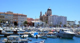
This old port is at the W church, a Byzantin round roof visible from anywhere in the bay. This small port is on the right and side of commercial quay. 230 berths (<60m)
Prohibited areas, the limits of which are shown on the chart, lie SW of Pointe du Titan (Ile du Levant) and extend up to 2 miles from the coast. These areas, which are used by French naval vessels, are not in force between July 1 and August 31. Vessels are prohibited from approaching ...


 2006-11-10


 Passe du bassin sud
 Large port with 2 basins N and S. Port sheltered from all winds, but care must be taken in very strong SE.
 Grand port au Sud Est de la ville, composé de deux bassins: N et S. Ce port est abrité de tous les vents, mais attention au très fort SE.