Petit port du Cros de Cagnes, limité aux petites embarcations. Entrée difficilement repérable du large. [http://snsm234.blogspot.com blog de la SNSM de Cros de Cagnes sur Mer]
Le Cap d'Ail marque la séparation entre les baies de Beaulieu et de Monaco. Les abords étant malsains, il faut s'en écarter assez largement. Le cap Martin est couvert de pins d'où émerge un sémaphore blanc sur les hauteurs.
The Presqu'ile de Saint Hospice , 40m high, forms a peninsula which extends E from the center of the E side of the Cap Ferrat promontory. It is surmounted by a chapel and a conspicuous tower Pointe Saint Hospice, located 1.2 miles NE of the Cap Ferrat Light, is the E extremity of ...
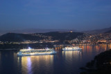
Small craft harbor, lies 2.3 miles NE of Port Marina Baie des Anges. It is protected by breakwaters and has extensive facilities for yachts. A boat basin lies 0.5 mile W of the harbor and is reported to be subject to silting.Port in the center of the Cote d'Azur close to Nice ...
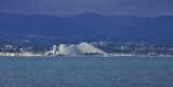
A small craft harbor, lies 3 miles NNE of Antibes. It is protected by two breakwaters and has extensive facilities for yachts. The harbor is backed by large pyramidal blocks of apartments which are very conspicuous from seaward.
MARINA BAIE DES ANGES includes: a total amount ...
Rade de Villefranche is entered between Pointe des Sans Culottes, the SE extremity of the Mont Boron promontory, and Pointe Malalongue, the SW extremity of Cap Ferrat, 1 mile SE. The bay extends N for 1.5 miles and offers sheltered anchorage to vessels of any size. It is used by vessels ...
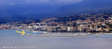
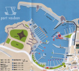
Antibes (Port Vauban) is an ancient town standing on a promontory which separates the harbor from the small bay to the S. The harbor has extensive facilities for pleasure craft, yachts, and fishing boats. Vessels can anchor E or NE of the harbor entrance, but the bottom of fine ...


 Cros de Cagnes
 Ce n'est plus la ville de cagnes qui le gère, mais la Métropole Nice Cote d'Azur
 Sur la photo, le San Martinu "Bateau d'Intérêt Patrimonial " restauré et naviguant à voile latine à coté le Florentéo
 Petit port du Cros de Cagnes, limité aux petites embarcations.