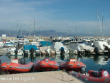
Antibes (Port Vauban) is an ancient town standing on a promontory which separates the harbor from the small bay to the S. The harbor has extensive facilities for pleasure craft, yachts, and fishing boats.
Vessels can anchor E or NE of the harbor entrance, but the bottom of fine sand is a poor holding ground and they are advised to anchor in Golfe Juan. Vessels can also anchor, in depths of 10 to 20m, E of the town.
The town is surrounded by fortifications and flanked by two large square towers. Fort Carre surmounts the point on the N side of the harbor and is prominent.
2012/03/28
Update
Port Vauban is the largest pleasure boat port in Europe! Visit Antibes at any time of year and you will soon realise that Antibes is about yachts, expensive yachts and very expensive yachts. The Old town is a must to visit with its narrow streets and varied restaurants.
Reception: near from BP st.
1700 berths
Grande Plaisance Basin: 19 berths (<70 to 150 m)
2016/01/17
Update
Joëlle
Port bien protégé dans une anse naturelle à proximité de la ville et des remparts. 1er port européen par la capacité à accueillir des navires de plaisance de grandes tailles.
Accueil près de la station d'essence.
longueur maximum des bateaux : 130m
1700 pl.
tel 04 92 91 60 00
Fax 04 93 34 74 04
Bassin de grande plaisance: 19 pl. (<70 à 150 m)
tel 04 93 34 30 30
Fax 04 93 34 27 52
Le quai Sud-Est est réservé à la grande plaisance.
2016/01/17
Update
Joëlle
Port Vauban è il più grande porto di imbarcazioni da diporto in Europa! Visita Antibes in qualsiasi momento dell'anno e ti renderai presto conto che Antibes parla di yacht, yacht costosi e yacht molto costosi. Il centro storico è un must da visitare con i suoi vicoli e ristoranti vari.
2021/07/19
Update
azerty
¡Port Vauban es el puerto de embarcaciones de recreo más grande de Europa! Visite Antibes en cualquier época del año y pronto se dará cuenta de que Antibes se trata de yates, yates caros y yates muy caros. El casco antiguo es una visita obligada con sus calles estrechas y variados restaurantes.
2021/07/19
Update
azerty
Share your comments or photos on "Antibes - Port Vauban"
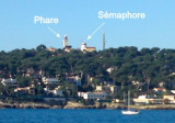
Le Cap d'Ail marque la séparation entre les baies de Beaulieu et de Monaco. Les abords étant malsains, il faut s'en écarter assez largement. Le cap Martin est couvert de pins d'où émerge un sémaphore blanc sur les hauteurs.
The highest point of the Cap d’Antibes peninsula. It dominates the E shore of gulf Juan. A light is shown from a square white tower with a red lantern, 24m high, standing on this point. A signal station and a prominent chapel are situated close NE and close SW, respectively, ...
The Presqu'ile de Saint Hospice , 40m high, forms a peninsula which extends E from the center of the E side of the Cap Ferrat promontory. It is surmounted by a chapel and a conspicuous tower Pointe Saint Hospice, located 1.2 miles NE of the Cap Ferrat Light, is the E extremity of ...
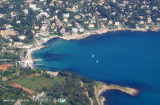
Anchorage can be taken, in depths of 18 to 20m, sand and weed, good holding ground, within Anse de La Garoupe, which is entered between Cap Gros and Pointe Bacon, 1 mile N.


 Entré du port avec le feu de musoir et le Fort Carré.
 2005-10-25
 Janvier 2009 - Antibes Port Vauban
 Antibes (Port Vauban) is an ancient town standing on a promontory which separates the harbor from the small bay to the S. The harbor has extensive facilities for pleasure craft, yachts, and fishing boats.
 Port bien protégé dans une anse naturelle à proximité de la ville et des remparts. 1er port européen par la capacité à accueillir des navires de plaisance de grandes tailles.
 Port Vauban è il più grande porto di imbarcazioni da diporto in Europa! Visita Antibes in qualsiasi momento dell'anno e ti renderai presto conto che Antibes parla di yacht, yacht costosi e yacht molto costosi.
 ¡Port Vauban es el puerto de embarcaciones de recreo más grande de Europa! Visite Antibes en cualquier época del año y pronto se dará cuenta de que Antibes se trata de yates, yates caros y yates muy caros.